Afghanistan is the country lying to the north-west of India. Its boundaries are, on the north, the Oxus or Amu Daria, from its source in Lake Victoria or Sir-i-Kul to Khoja Saleh, and thence a line drawn across the Turkoman desert south-westward to the Murghab, passing south of Panjdeh, and touching the Hari-Rud at Zulfikar. This line has been demarcated in accordance with the London protocol of 1885 and the St Petersburg treaty of 1887. On the north-east, Afghanistan is bordered by a mountainous region, inhabited by tribes of various nationalities, but for the most part speaking Afghan dialects, and settled in the fertile but almost inaccessible valleys of the Upper Indus and its tributaries. On the east, the frontier runs along the eastern foot of the Suliman Mountains; but here again some of the tribes are almost independent, and the Indian government controls the more important passes. On the south, a line passing north of Quetta in about the 30th parallel of N. lat., divides Afghanistan from the territory of the khan of Kalát and Beluchistan; while on the west, the meridian of 61° E. long. would approximately define the boundary with Persia.
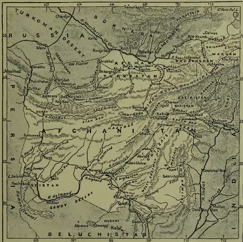
Within these limits, Afghanistan extends 400 miles from north to south, and 600 miles from east to west, and contains an area which may be roughly estimated at 240,000 sq. m., or about twice the size of Great Britain and Ireland. This includes Badakhshan and Wakhan in the north-east, and Afghan Turkestan in the north, comprising the Uzbek States of Balkh, Kunduz, Maimana, Shimbarghan, Khulm, Akchá, and Andkhói, owning allegiance and paying tribute to the Ameer. Afghanistan may be divided into the three great river-basins of the Oxus, the Indus, and the Helmand. (1) Oxus basin. The northern slopes of the Hindu Kush are drained by a number of rivers flowing northwards towards the Oxus; only two, however—the Kokcha and Kunduz—reaching that river, while the remainder are either absorbed in irrigation, or disappear in the sands. The westernmost of the series—the Murghab and Hari-Rud—are of great importance, owing to the geographical position and fertility of their valleys, affording two lines of approach to Herat from the north. (2) The Indus basin includes the great basin of the Kabul itself and its tributaries, draining the southern slopes of the Hindu Kush and the northern valleys of the Safed-Koh; the basin of the Kuram, commanding a well-known approach to Kabul from the Indian frontier at Thal; and the streams issuing from the Waziri hills and Suliman range. (3) The Helmand, with its three great tributaries, the Argandab, Tarnak, and Arghastan, drains all South-western Afghanistan. Afghanistan is for the most part an arid, mountainous country, and cultivation is only met with in some of its valleys.
According to Holdich, the principal mountain systems of Afghanistan are the Hindu Kush, with its westerly continuations, the Koh-i-Baba, Paghman, Safed-Koh, and Siah-Koh. The Hindu Kush takes its rise in the north-east, where it abuts on the north-western end of the Himalayas in a group of magnificent peaks, rising to a height of 23,000 feet above the sea. Hence it extends in a south-westerly direction to the Khawak Pass as a single range of great height. Farther west it diminishes in altitude, and divides into a system of parallel chains, with high plateaus and valleys between them. The Safed-Koh, not to be confounded with the range of the same name in North-western Afghanistan, divides the Kabul from the Kuram, and has no geographical connection with the Hindu Kush, while the Suliman hills form the edge of the plateau on the Indian side. The climate of Afghanistan is as diversified as its physical configuration. At Ghazni (7279 feet) the winter is extremely rigorous, and for several months the inhabitants are snowed up in their houses. At Kabul (5600 feet) the cold is severe for two or three months, but the summers are temperate. At Kandahar the winters are milder, but the heat in summer is intense (110° F. in the shade). The climate of Seistan, in the south-west of Afghanistan, is hot and trying; while that of Herat, in the north-west, is temperate; though here, as in other parts of Afghanistan, violent north-westerly winds and dust-storms are frequent.
Fever, intermittent and remittent, and diseases of the eye, are among the most common complaints of the Afghans. The population of Afghanistan is composed of a variety of nationalities, and is estimated at about 4,900,000. The Afghans proper, or Pathans, number about 3,000,000, and are divided into tribes or clans—Durānis, Ghilzāis, Yūsufzāis, and others. The
Durānis are the dominant tribe; the Ghilzāis, the strongest and most warlike; the Yūsufzāis, the most turbulent. Of the non-Afghans, the Tajiks are probably the most numerous, and are the agricultural and industrious portion of the population; the Hindkis and Jāts chiefly live in the towns, and are traders; the Kizilbashes are Turko-Persians, and form the more educated and superior class; while the Hazāras, a race of Mongol origin, in the mountainous districts on the north-west of Afghanistan proper, are nomads. The Afghans claim descent from King Saul, and call themselves 'Bani Israel;' but though their features are of a Jewish type, and some of their customs have a curious analogy to those of the Jews, their language—the Pakhtu or Pushtu—has no affinity with the Semitic tongue, but rather belongs to the Aryan family. In religion they are Sunni-Mohammedans. In character they are proud, vain, cruel, perfidious, extremely avaricious, revengeful, selfish, merciless, and idle. 'Nothing is finer than their physique, or worse than their morale,' says an intelligent observer.
The Afghans do not as a rule inhabit towns, except in the case of those attached to the court and heads of tribes. The townsmen are mostly Hindkis and other non-Afghan races, who practise various trades and handicrafts considered derogatory by men of rank. The houses or castles in the country are all enclosed by high walls, and contain three or four different courts, laid out in gardens, with ponds and fountains, much the same as in Persia and Turkestan. The principal towns are Kabul (population 140,000), the seat of government and centre of a fertile district; Ghazni, a strong fortress; Kandahar, the chief city of Southern Afghanistan, with 30,000 inhabitants; and Herat, formerly considered the key of India. Among towns of secondary importance are Charikar, Istalif, 20 miles NNW. of Kabul, and Farah in Seistan.
Among the natural productions of Afghanistan is the plant yielding the asafœtida. The castor-oil plant is everywhere common, and good tobacco is grown in the district of Kandahar. Aitchison says that the cultivated area round Herat produces magnificent crops of wheat, barley, cotton, grapes, melons, and the mulberry-tree; the production being only limited by the amount of labour procurable. Surrounding the villages, and in orchards, the ash, elm, apricot, apple, plum, quince, peach, and pomegranate are cultivated; the sanjit (Eleagnus orientalis), yielding an edible fruit, and the zizyphus are indigenous. In special localities are forests of pistachio, its leaves being used in dyeing. The general appearance of the country during winter is barren and arid in the extreme, owing to the absence of trees and woody shrubs; but in spring a mass of vegetation springs up, giving a grand colouring to the landscape. The industrial products are silk, chiefly for domestic use, and carpets, those of Herat being of admirable quality. The manufacture of postins, or sheepskins, is one of the most important of the industrial occupations of the people, and of late years the trade in this article has greatly increased. Afghanistan is crossed by several trade-routes leading to India on the one side, and to Persia and Turkestan on the other; merchandise, however, is all transported on camel or pony back. Commerce suffers much from frequent wars and bad government. There is, however, some export of Afghan productions, particularly carpets to India; and Indian textile fabrics meet with a ready sale in Afghanistan.
The history of Afghanistan as an independent state only dates from the middle of the 18th century. For two centuries before, Herat and Kandahar had been in the possession of Persia; while
Kabul was included in the Mogul empire of Delhi. Upon the death of Nadir Shah in 1747, Ahmed Shah Durāni subjugated the different provinces, and when he died in 1773, left an empire to his son, Timur Shah, extending to the sea of Oman on the south, and on the east to the mountains of Tibet, the Sutlej, and the Indus. Timur Shah reigned twenty years, and dying in 1793, left thirty-six children, of whom twenty-three were sons. The rivalries and jealousies among these princes or sirdars, their attempts to concentrate absolute power in their own hands, their turbulence, cruelty, and treachery, kept Afghanistan in a constant state of warfare, and led to the interference, first of Persia, and then of the British. In 1809 Mountstuart Elphinstone was sent as ambassador to Kabul, and concluded a treaty with Shah Shuja, son of Timur Shah, at Peshawar. Shah Shuja soon afterwards abdicated, and his brother, Mahmud Shah, took possession of the throne. His vizier, Futtel Khan, restored prosperity to Afghanistan for a while, but was blinded and afterwards murdered. His death was avenged by his brothers, the ablest of whom, Dost Mohammed, made himself master of Kabul in 1826.
In 1834 Shah Shuja made an effort to recover his throne, and entered Afghanistan with an army of twenty thousand Afghans and Hindustanis, but was defeated by Dost Mohammed. The siege of Herat by the Persians in 1837, when it was successfully defended mainly through the exertions of Lieutenant Eldred Pottinger, and Dost Mohammed's signal victory over the Sikhs, attracted the serious attention of the British government. Lord Auckland, then governor-general, declared war against Afghanistan in 1838, on the grounds that Dost Mohammed had unlawfully attacked the British ally, Runjit Singh; that the military operations of the Afghans had betrayed a hostile purpose towards India, and that Shah Shuja, as the rightful heir to the Afghan throne, had placed himself under British protection. It was designed to establish a friendly power in Afghanistan, which should form the first line of defence against the threatened advance of Russia on India. In pursuance of this policy, on the 16th January 1839, an army of 21,000 men, under the command of Lieutenant-general Sir John Keane, crossed the Indus, advanced without opposition through the Bolan Pass, and took possession of Kandahar. Ghazni was taken after some hard fighting, and on the 7th August, the Anglo-Indian army entered Kabul, where Shah Shuja was proclaimed Ameer. Dost Mohammed, deserted by his forces, retired beyond the Hindu Kush, and the conquest was regarded as complete. Sir William Macnaghten and Sir Alexander Burnes were established at Kabul as British political agents; and a body of Anglo-Indian troops was stationed there under General Elphinstone.
Events, however, soon showed that the British had altogether mistaken the character of the Afghans. Though Dost Mohammed had surrendered, his son Akbar Khan was actively engaged in a conspiracy, and on the 2d November 1841 an insurrection, caused, it is said, by the reduction of subsidies to the Afghan sirdars, broke out at Kabul. Burnes and his brother were hacked to pieces with Afghan knives, Macnaghten was treacherously shot seven weeks later at a conference with the Afghan sirdars, several British officers were slain, and the Anglo-Indian army, after being besieged in cantonments for sixty-five days, capitulated. It was then agreed that they should leave the country, and that Akbar Khan and his confederates should make arrangements for their retreat, and provide an escort. Depending on these promises, the British troops left Kabul on the 6th
January 1842, to return to India; but neither escort nor provisions were supplied, and the severity of the season increased the misery of the retreat. The fanatical tribes of the district harassed them on all sides, and out of 16,500, of whom 12,500 were camp-followers, only one man (Dr Brydon) escaped to carry the dismal tidings to General Sale at Jelalabad. To retrieve this disaster, General Pollock, in September 1842, advanced on Kabul, routed Akbar Khan, and having inflicted punishment on the Afghans, and rescued the English officers and ladies who had surrendered themselves as prisoners, led his army back to India.
Henceforward the policy of the new governor-general, Lord Ellenborough, was to be one of non-interference in the affairs of Afghanistan, and it was hoped that the Afghans would keep the peace. Soon afterwards, however, forming an alliance with the Sikhs, they assisted them in their war against the British, till a crushing defeat was inflicted on their combined forces by Lord Gough, at the battle of Guzerat, on the 21st February 1849, and Dost Mohammed fled across the Indus. On the 30th March 1855, he concluded a treaty with the British, and in 1863, soon after the capture of Herat, which he had besieged for ten months, he died, and was succeeded by Shere Ali Khan, one of his younger sons. At first, the choice was acquiesced in by the other brothers, but disagreements soon arose, which for many years kept Afghanistan in a state of anarchy, and at one time the fortunes of the Ameer Shere Ali Khan were at a low ebb. The loss of a favourite son at the battle of Kajbáz (on the 6th June 1865) affected him so seriously that he ceased to interest himself in public affairs, and remained at Kandahar, while his rebellious half-brothers, Mohammed Afzul Khan, and Mohammed Azim Khan, with Abdul Rahman Khan, the son of the former, were gaining repeated successes, and alienating the country from his rule. The capture of Kabul at length aroused him to action. Taking the command of his forces in person, he led them against the entrenched position of the enemy; but notwithstanding the impetuosity of the assault, and his personal gallantry, he was defeated, and fled with a small following towards Ghazni and Kandahar. Other attempts to restore his fallen fortunes were equally unsuccessful, and it was not till 1868 that he at length regained possession of Kabul. In that year he received assistance from the viceroy of India, Sir John Lawrence, to secure the position for which he had fought so hard. The next viceroy, Lord Mayo, met the Ameer in state at Anbála, in March 1869. At this meeting, it was explained to him that Her Majesty's government had no desire to interfere with the affairs of Afghanistan, except to check civil war, and by so doing, to secure the peace and prosperity of the country. This intimation was accompanied by another large present.
In 1870 the Ameer's eldest son, Yákub Khan, who had shown great ability as governor of Herat, and had, on many occasions, given his father valuable assistance, broke into open rebellion against him. In 1873 Abdulla Ján was proclaimed heir-apparent, and in 1874 Yákub was imprisoned by his father at Kabul. For some time previous to 1878 there had been an estrangement between Shere Ali and the British government; he had then made overtures to Russia, and had welcomed at his capital a Russian mission. In consequence of these new relations with Russia, Shere Ali was invited to receive a British mission; his refusal led, after some fruitless negotiations, to war, and hostilities began by forcing the entrance to the Khyber Pass towards the end of November. Severe fighting followed, but the English were everywhere successful. Before the end of December, Jelalabad was occupied without resistance, and Kandahar a little later. Shere Ali fled from Kabul for Turkestan, and died at Mazar-i-Sharif towards the end of February 1879. Yákub Khan was proclaimed Ameer in the following month, and on the 26th May signed a treaty of peace with the British at Gandamak. It was provided that our representative should reside at Kabul, and that the British government should defend Afghanistan from foreign aggression, the Ameer receiving a subsidy; whilst the Kuram, Pishin, and Sibi valleys, the Khyber and Michni passes, were to remain under the control of the British government as part of a line of scientific defensible frontier for India. This settled matters for a time, but in September of the same year, the revolted troops of the Ameer surrounded and attacked the British residency. The Resident, Sir Louis Cavagnari, and his staff, with almost the whole of their Indian guard, were cut to pieces, after a desperate and gallant resistance. Measures were immediately adopted for punishing this outrage. Sir F. Roberts, with a force of over 6000 men, after defeating the Afghans at Charásia, 12 miles from Kabul, on the 6th October, took possession of that city on the 12th, when Yákub Khan abdicated, and put himself under British protection. All went well for two months, but early in December there were gatherings of the tribes in the neighbourhood of Kabul. Attempts to disperse them were defeated, and the British were beleaguered for ten days in their cantonments at Sherpur. The arrival of reinforcements, under General Gough, enabled them once more to take the field, and the war was continued in a desultory way.
In June 1880 Ayub Khan, a younger brother of Yákub Khan, the ex-Ameer, proclaimed a ghaza, or holy war, and announced his intention of marching on Kandahar, then in the possession of the British. A brigade under Brigadier-general Burrows was sent against him. On the 27th July, Burrows marched to attack Ayub at Maiwand, and was completely defeated, with the loss of over 1000 killed and wounded. A second reverse followed in August, when Brigadier-general Brooke's column was attacked, and had to retire with heavy loss, that officer being killed. Abdul Rahman Khan, who had been a pensioner of the Russian government in Samarkand from 1870 to 1880, in the meanwhile had come to terms with the British government, and had in July been recognised as Ameer. The withdrawal of the army of occupation had been decided on, when news of the Maiwand disaster was brought. To avenge this, General Roberts marched with a force from Kabul on the 9th August, and reached Kandahar on the 31st. On the following day he totally defeated Ayub Khan, the Afghan camp, artillery, and baggage falling into his hands, whilst Ayub himself escaped with a handful of horse. Before withdrawing, the British troops reduced to submission some refractory tribes, and completed the evacuation of Afghanistan by the end of April 1881. Abdul Rahman Khan, with the assistance of the British government, made himself master of the whole country.
Russia's proposal, in 1882, to delimit the frontier of Afghanistan was received coldly in England. In July 1884, however, a commission was appointed to demarcate the boundary between Afghanistan and the territory of the Turkomans. General Sir Peter Lumsden was nominated by the British government, and General Zelenoi by the Russian. The line on which the commissioners were to be engaged was from Kwája Sala on the Oxus, to Sarakhs. But after the annexation of Merv and the preliminary surveys of M. Lessar, in the valleys of the Khushk and Murghab, the Russian authorities took a different view. They contended that the Paropamisus was the true boundary of Herat, and that the district of Badghis, inhabited by Saryk Turkomans, who had proffered their allegiance to the Czar, lay outside Afghan territory. Questions of such grave moment, it was further stated, required to be settled by the two European governments before the commissioners could enter on their duties, and General Zelenoi was, without further explanation, sent to Tiflis. General Lumsden waited for him for four months on the Murghab, with an escort of 500 men, besides followers. In the meanwhile, the Russian outposts were advanced so as to include part of the debatable land. By their occupation of Zulfikar, 50 miles south of Pul-i-Khatun, the outposts of the two nations were brought into immediate contact, and it was only through the urgent remonstrances of General Lumsden that a collision was avoided. Matters were further complicated by the attack on Panjdeh, near the fork of the Khushk and Murghab rivers, by a force under the command of General Komaroff, on the 30th March 1885, and by his seizure of this important strategical position. During 1886 the demarcation of the frontier was proceeded with, and in April 1887 the British and Russian commissioners met at St Petersburg. After somewhat protracted negotiations, an agreement was effected, resulting in a compromise of the points at issue, concessions having been made on both sides. Russia obtained the valleys south of Panjdeh for 9 or 10 miles in the direction of Herat; on the other hand, the Ameer of Bokhara waived his claims to the pasture-lands on the left bank of the Amu Daria, south of Khoja Saleh. Russia now touches the north-western frontier of Afghanistan, and has developed her railway communication in this direction with extraordinary rapidity. Meanwhile Britain has fortified and garrisoned Quetta in Beluchistan, on the southern frontier of Afghanistan, and connected it with India by a railway extended (1887) to Pishin. In 1893 the Ameer received a British mission under Durand, which arranged a rectification of frontier, excluding Chitral, Swat, and Waziristan, and including Kafiristan.
See Elphinstone's Cabul (1815); Kaye's War in Afghanistan (1851; 4th ed. 1878); histories by Malleson (1878) and Raverty; the Life of Abdul Rahman by Wheeler (1895); Reports by Lumsden and Macgregor; and books by Bellew (1879), Oliver (1890), and J. A. Gray (1895).