Bermudas, or SOMERS' ISLANDS, British possessions in Mid-Atlantic, were so named respectively from Bermudes, a Spaniard, who first sighted them in 1515, and from Sir George Somers, an Englishman, whose shipwreck here in 1609 was the immediate occasion of their being colonised from Virginia—itself only four years old—in 1611. This low and lonely archipelago is a mere group of specks; for though it numbers perhaps 100 islets and more than twice that number of rocks, yet it measures only about 12,000 acres in all, the whole occupying a space of about 14 miles in length by little more than 5 in breadth. The islands are composed of blown coral sand, and are surrounded by a living, growing reef of coral, the whole being a modified Atoll (q.v.), and the most northerly of such structures. The great value of this natural fortress as a British naval station, defended by its extensive barrier of reefs and rocks, with only one or two intricate channels, arises from its situation. In 32° 15' N. lat., and 64° 51' W. long., the Bermudas occupy, commercially and politically, a singularly commanding position. At a distance of 580 miles from Cape Hatteras, in North Carolina, they are about equally remote from the north of Maine and from the south of Florida; while they are a connecting link between Canada and the British West Indies. In the principal or Main Island is situated the present seat of government, Hamilton, on a deep inlet running 2 or 3 miles into the land. St George's, the island next in importance, contains the picturesque town of the same name, and a land-locked harbour, the entrance to which is defended by strong batteries. Ireland
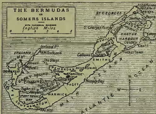
Island is entirely occupied by Her Majesty's Dockyard and other naval establishments; and Boaz and Watford Islands have the military depôts and garrisons. At Ireland Island also is the celebrated Bermuda Floating Dock, built in England, and towed out in 1869. It is 381 feet in length by 124 feet in breadth, and is sufficiently powerful to lift a ship of the Minotaur class. The minor islands of St David, Cooper, Smith, Nonsuch, Godet, and others, form numerous picturesque creeks and bays of great size and depth, such as the Great Sound, Castle Harbour, Harrington Sound, and others. Most of the other islands are insignificant, many of them without name or inhabitant. The group forms an almost continuous chain, and, with one break, there is uninterrupted communication by roads, causeways, and bridges for a distance of about 22 miles; but from the strange shapes of most of the islands, and the number of spacious lagoons, the communications are almost as necessarily by water as are those of Venice. The climate is tempered by an almost constant sea-breeze, and the air is moist at all seasons. The thermometer never falls below 40° F., and seldom rises above 85°. The islands are becoming a popular holiday and winter resort, especially for Americans, and both Hamilton and St George's are plentifully supplied with hotels and shops. The climate, however, is not suited for consumptive invalids. The soil is poor in quality, and not more than a fourth is cultivable at all; but there being no winter frosts, crops can be prepared for March, April, May, or June, and the large quantities of early potatoes, onions, tomatoes, and other garden vegetables, which in these months fetch high prices at the New York markets, enable the Bermudians to live comfortably on the income of their comparatively small portions of ground.
Besides being useful as a station for those British vessels of war which are charged with the care of the West Indies on the one side and the northern provinces on the other, Bermuda was formerly an important depôt for convicts, but since the year 1862 it has ceased to be so. There is a regular fortnightly mail service with New York, and a weekly service in the early spring. The colony has no railways, but has a very complete telegraph system. Pop. (1871) 12,121; (1881) 14,314, including 5384 whites, 5564 coloured persons, and 266 civilians in the naval and military establishments; (1891) 15,013. The exports vary from £65,000 to £140,000 a year; the imports from £270,000 to £330,000. The revenue, over £30,000, covers the expenditure; the debt is £10,000. The fisheries are productive. As their own early crops are too valuable for home consumption, the Bermudians import grain, flour, rice, and also livestock from the United States. The group is under the authority of a governor and council of 9 members appointed by the crown; and an assembly of 36, four of whom are elected by each of the nine parishes. Hamilton and St George's have each a mayor, three aldermen, and five councillors. The schools are mostly private, and charge fees, but are aided by public grants, under the supervision of a Board of Education. In September 1899 an unusually severe cyclone visited the 'still vexed Bermoothes'—of which Bermuda is now the accepted spelling. More than two-thirds of the population belong to the Church of England, which has five clergymen, under the Bishop of Newfoundland and Bermuda; the Presbyterians have two, the Wesleyans three ministers, and other bodies are also represented. Under a temporary act, all churches are endowed at the rate of £10 for every 100 members. See works on Bermuda by Lefroy (1882), Ogilvy (1883), Dorr (New York, 1884), Stark (Boston, 1884), and Heilprin (Phila. 1890); and the Annual Bermuda Pocket Almanac, Guide, and Directory.