Canal. A canal is an artificially-formed channel filled with water, and though it generally denotes a channel used for navigation, it is also applied to channels made for drainage and irrigation.
Drainage Canal.—A drainage canal is an artificial watercourse formed to supplement the rivers, which are the natural drains of a country, where, owing to a deficiency of fall and the low level of the adjacent lands, the rivers are inadequate for discharging the surplus rainfall in wet seasons, and the lands are in consequence exposed to floods. Many instances of such canals exist in Holland, and in the Fen districts of Lincolnshire and Norfolk, where they are termed drains or cuts, as for example the Hobhole Drain and the Eau Brink Cut; and they differ from ordinary Rivers (q.v.) merely in being straight artificial cuts, instead of natural channels formed by the flow of the drainage of the district. As these drains are generally constructed across a country where there is little slope towards the sea, they have to be given a large section in relation to the water they are designed to carry off, as the discharge of any watercourse is proportionate to its fall. By embanking each side with the material excavated in forming the canal, and especially by placing these longitudinal embankments a little distance back from the edges of the cut, an enlarged channel is economically provided for the flood discharge, as soon as the water rises above the ordinary surface-level, without exposing the land to inundation.
Irrigation Canal.—The object of an irrigation canal is to lead the waters of a river, flowing through a hot dry country, on to lands at a distance from the river bank, and so preserve them from drought, and increase their fertility. Considerable tracts of the Lower Nile valley are irrigated in this manner; the rice crops of India are largely dependent upon the supply of water conveyed by irrigation canals; and important irrigation works have been carried out in Italy and Spain, as also in California and Colorado. These canals, being designed like drainage canals for the conveyance of water, are made with a regular fall or slope, so that the water may flow along the canal. By increasing the fall, the size of the channel may be proportionately reduced for a given discharge; but it is inexpedient to augment the fall, even if practicable, beyond the limit at which the increased velocity of flow thereby induced begins to scour the bed of the channel—as occurred on the Ganges Canal, necessitating works for checking the flow. Sluices and weirs have to be constructed at the intakes of these canals for regulating the supply, and sometimes for shutting it off on the approach of a high flood; and arrangements have to be provided for the due admission of the water into the branch canals and trenches which serve to distribute the water over the area to be irrigated. The details relating to these works appertain to Irrigation (q.v.); and the formulae for determining the flow, and consequently the requisite section of a drainage or irrigation canal with a given available fall, form a branch of hydromechanics.
Navigation Canal.—Though drainage and irrigation canals are sometimes used for the transit of vessels, they are designed for the passage of water; whereas navigation canals are level still-water channels solely constructed as a waterway for vessels, just as a road is formed for vehicles, and a railway for trains. Unlike roads or railways, however, canals cannot adapt themselves to the irregularities of the country they traverse, by varying slopes or gradients, but must be formed of a series of level reaches, at different heights according to the lie of the country, connected at their extremities by locks or other means of transferring boats from one reach to the level of the adjoining reach. This renders the laying out of canals more complicated than that of railways, owing to the necessity of selecting the most suitable routes for long level reaches; though the work is facilitated by cuttings, embankments, aqueducts, and occasionally tunnels, as in the case of railways.
A canal should be generally wide enough for two of the largest-sized barges navigating it to pass easily; and, to avoid the resistance to traction in a restricted waterway, it is expedient that the bottom width should be twice the greatest breadth of beam, the depth feet more than the greatest draught, and the section of the waterway six times the greatest midship section of a barge. The bottom is made flat, and the sides with slopes of to feet per foot; but through towns, vertical side walls are substituted to save space and provide quays. In tunnels and deep cuttings, the width is usually made only just sufficient for a single barge; and passing places are formed at suitable intervals. On embankments, and along cuttings in a porous soil, a watertight lining of clay-puddle or concrete has to be added, to retain the water in the canal. A towing-path along one side of the canal, raised about two feet above the water-level, affords facilities for haulage.
An ample supply of water is essential for a canal, to make good the losses occasioned by leakage, evaporation, and lockage. Leakage results from defects in the watertightness of the channel, and escapes of water under pressure at the lock-gates, and depends therefore upon the state of repair of the canal. The loss from evaporation is proportionate to the exposed water-surface, and is greatest in summer when the supply of water is the least. The expenditure of water in locking is dependent on the size of the lock-chambers, the difference between the levels of the reaches, which is termed the lift of the locks, and the amount of traffic on the canal. There is no difficulty in the supply of water to canals in low-lying districts, such as Holland and parts of Belgium; and even in most parts of river valleys, streams are generally available for introducing a supply at various points. When, however, a canal rises to the higher portions of a river basin, and crosses the ridge separating two adjacent basins, in a reach called the summit-level of the canal, a very common course for inland canals, it is sometimes difficult to secure an adequate supply, especially for the summit-level; so that occasionally an artificial Reservoir (q.v.) has to be formed, at a high level, by con- structing a dam across the valley of a mountain stream, which, by storing up the winter flow of the stream, is enabled to furnish a continuous supply in the summer. A deficiency of water has led to the adoption of expedients for saving water in locking, and sometimes to the use of other means of transferring vessels from one reach to another, especially when the difference of level is considerable.
Vessels may be transferred from one reach of a canal to the next, either by a lock, an incline, or a lift.
Lock.—A lock is a watertight chamber, closed by gates at each end, separating two adjacent reaches of a canal, which by means of sluices can be filled with water from the upper reach to the level of the upper reach, or emptied to the level of the lower reach; so that vessels can be admitted from either reach, and raised or lowered to the level of the other reach by merely filling or emptying the lock-chamber. Where the difference of level is considerable, a series of locks are placed end to end in steps, forming what is termed a flight of locks. Locks involve a considerable expenditure of water when the traffic is large, for a lockful of water is required for each pair of boats passing through a single lock, when boats ascend and descend alternately; whilst, when the boats ascend and descend in a series, a lockful of water is expended on each boat, except the last or first of a series. With a flight of locks, boats passing up and down in a series cause the least expenditure of water; whereas each pair of boats passing up and down alternately, require as many lockfuls as the number of locks in the flight. Accordingly, to save water, a second flight is sometimes placed alongside the other, so that one may be used for ascending, and the other for descending boats. Side ponds, into which the upper layers of water may be discharged in emptying a lock, and utilised again for refilling the lock, are sometimes used for economising water in locking. For further details, see LOCK.
Incline.—Occasionally, where water is scarce, and the lift large, vessels are conveyed on an incline from one reach to the next, in a special carriage running on rails laid on the incline, and controlled by a cable. The vessel is either lifted on a cradle out of the water; or it is floated into a wrought-iron caisson, or trough, containing water, with lifting gates at each end, and supported on a frame so constructed that the caisson is conveyed in a horizontal position up or down the incline. In the cradle, the barge is conveyed on the incline in a sloping position, and the support afforded by the water to a loaded boat when immersed is removed; whilst, in the caisson, the vessel is carried in the same position, and under the same conditions, as in a canal; but the load on the incline is increased by the larger carriage and the water in the caisson. By connecting the cables of the ascending and descending loads on the drum at the top of the incline, the work of haulage is greatly reduced.
Very primitive inclines were employed on the ancient canals of China, the boats being hauled up by a capstan, and made to slide down the paved track. The first incline with counterbalanced cars running on rails appears to have been adopted on the Ketley Canal in Shropshire, in 1788, for surmounting a height of 73 feet; and others were soon after established on the adjoining Shropshire Canal. On the Morris Canal, in New Jersey, U.S., there are twenty-three inclines, with an average rise of 58 feet, on which boats of 80 tons are drawn in cars up a gradient of 1 in 10; four inclines on the Oberland Canal, in Prussia, of which the largest has a height of feet, were completed in 1860; and another has recently been substituted for the five lowest locks on the canal.
Caissons were first adopted for inclines on the Chard Canal, in Somersetshire, and subsequently, on a larger scale, on the Monkland Canal, near Glasgow. The largest caisson, weighing 390 tons when full, was put on the incline at Georgetown in 1876, which replaced two locks connecting the Chesapeake and Ohio Canal with the Potomac. The incline is 1 in 12, and 39 feet high; and boats of 115 tons are readily transferred from the lower to the upper reach in from 8 to 16 minutes, the haulage being effected by iron-wire cables moved by a turbine.
Lift.—A canal lift consists of two iron troughs, filled with water, which counterbalance one another, one going up as the other descends vertically, and thus raising or lowering a boat from one reach to the other. A lift has the advantage over a flight of locks in effecting an economy in water, space, time occupied in working, and even, under certain conditions, in cost of construction. A simple canal lift was erected in 1838 on the Grand Western Canal in England, which raised or lowered boats of 8 tons a height of 46 feet, in three minutes, by admitting an excess of one ton of water into the top trough, but it has been abandoned. Hydraulic canal lifts have been only recently introduced, the first having been opened for traffic in 1875, at Anderton, for connecting the Weaver with the Trent and Mersey Canal, the difference of level being 50½ feet. Two troughs, 75 feet by 15½ feet, each supported in the centre by a hydraulic ram, and containing 5 feet depth of water, balance one another; and the main portion of the motion is effected by removing 6 inches in depth of the water from the bottom trough, the final lift only of the ascending trough, of about 4½ feet, being accomplished by the hydraulic ram, 3 feet in diameter, underneath it. A barge of 100 tons can be lifted in the trough in two and a half minutes; and barges can be transferred from one level to the other, in both directions, in eight minutes; whereas over one hour is expended in passing through a flight of locks having an equal rise. Another similar lift has been erected at Les Fontinettes, near St Omer, on the Neufossé Canal, with a lift of 43 feet, in substitution for a flight of five locks which had become inadequate for the large traffic from Boulogne, Calais, and Dunkirk, to Paris, which is carried on the canal in barges of 300 tons. Each trough is 132¾ feet long and 18½ feet wide, with a depth of water of 6½ feet; and the weight moved is 700 tons. On one of the sections of the Canal du Centre, in course of construction in Belgium, a difference of level of 220 feet, in a distance of 5 miles, is to be surmounted by four lifts, of which the first was commenced at La Louvière in 1885. The troughs are similar to those at Les Fontinettes; but as they are to receive boats of 400 tons, the depth of water has been increased to 8½ feet, and the total weight raised is about 1100 tons.
History of Canals.—Canals were constructed in Egypt, China, Assyria, and India, in remote antiquity; but till the invention of the pound lock, supposed to have been first introduced in Italy in the 15th century, canals could not be suitably adapted for traversing irregular country; after which canals were gradually extended throughout Europe. The first European canals on the Continent were constructed in Italy, in the 12th century, for irrigation, and were subsequently utilised for navigation. The earliest canal in France was carried out in 1605–41, for connecting the Seine and the Loire, a very useful class of canal, forming a link between two river navigations, of which numerous examples now exist with great advantage to the development of inland navigation. The second canal constructed in France, in 1666–81, was a more ambitious scheme; and by connecting the Bay of Biscay with the Mediterranean, thus avoiding the long detour by the Strait of Gibraltar, proved the prototype of modern ship-canals; though, as its depth is only 6½ feet, it is not adapted for vessels of above 100 tons. The Gironde and the Garonne give access up to Toulouse; and from this point, the Languedoc Canal, or Canal des deux Mers, 148 miles long, rises gradually by locks to a summit-level of 600 feet at Naurouse, and then descends in a similar manner to Narbonne on the Gulf of Lyons, the number of locks being 119. A scheme was under discussion in 1887 for enlarging the canal so as to render it available for the sea-going craft of the present day. The enlargement and extension of canals and the improvement of rivers have been vigorously pursued by the French government simultaneously with the development of railways; and a large proportion of the bulky goods (amounting to over 1384 million tons carried 1 mile in 1882) are conveyed by water in France. There are about 3000 miles of canals in France, and 2000 miles of canalised rivers, in addition to nearly 2000 miles of open river navigation; and many of the waterways are free of toll, the costs of construction, improvement, and maintenance being paid by the state. To obtain uniformity in the principal canals, constructed at different times and under variable conditions, a law was passed in 1879, for securing eventually a depth of water of 6½ feet, locks 126½ feet long and 17 feet wide, and a clear height of 12 feet under the bridges, along the main lines of traffic. As soon as the necessary works are completed, boats of 300 tons, 126½ feet long, 16½ feet wide, and 6 feet draught, will be able to traverse all the principal waterways of France.
Canals were introduced into Holland and the level parts of Belgium in the 12th century; and being independent of locks in a flat country, and amply supplied with water in a low-lying district, they promoted the traffic which rendered Flanders the emporium of commerce in the 14th century. The canal system has continued to flourish in these countries; and Amsterdam and Rotterdam, like Venice, are intersected by canals.
The Russians have executed considerable canal works for connecting their large rivers; for instance, the Volga and the Neva are connected by a canal which admits of the passage of vessels of 500 to 1000 tons. A scheme for connecting the Volga and the Don is in contemplation, to afford the Volga an outlet into the Black Sea, by a canal, 35 miles long, which will have to surmount a difference of level at its extremities of 126 feet, with a greater height at its summit-level, and is to be available for vessels of 500 tons. Its estimated cost is nearly £4,000,000.
The earliest canals in England were the Foss Dyke and Caer Dyke, in Lincolnshire, 11 and 40 miles long, constructed by the Romans, and improved in the 12th century; and the Foss Dyke is still navigable. The opening of the Aire and Calder Navigation, towards the close of the 17th century, was the first important step in inland navigation in England; but the development of canals in Great Britain, in the latter half of the 18th century, was mainly due to the energy and resources of the Duke of Bridgewater (q.v.), and the skill of his engineer, James Brindley (q.v.), who designed and carried out several of the earlier canals, commencing with the Bridgewater Canal, completed in 1772. A great number of canals were constructed between 1788 and 1805; a canal mania, similar to subsequent railway manias, occurred in 1791–94; and the last inland canal was completed about 1834. The depth of most of the canals ranges between 3½ and 5 feet; the smallest lock is 72 feet long, 7 feet wide, and 4 feet depth of water over the sill, and the largest, on the Aire and Calder, 215 feet by 22 feet by 9 feet, with a variety of intermediate sizes. Railways have caused a great decrease in the canal traffic in England; but some waterways, such as the Aire and Calder and the Weaver navigations, and the Gloucester and Berkeley Canal, compete successfully with railways for heavy goods. Indeed, if the canals had not partially fallen into the hands of the railway companies, and if an effort had been made to secure uniformity in depth and in the size of locks on the principal lines, as in France, it is probable that a fair traffic would have been maintained with great benefit to the country. There are 3050 miles of canals in England, 154 miles in Scotland, and 609 miles in Ireland, making 3813 miles of canals in the United Kingdom; whilst 120 miles of canals have been converted into railways. The largest canals of Great Britain are the Gloucester and Berkeley Canal, with a depth of 15 feet, enabling vessels of 600 tons to go from Sharpness to Gloucester, a distance of 17 miles; the Aire and Calder Navigation, 9 feet deep, on which steam-towage with a train of barges has been successfully carried out; the Caledonian Canal (q.v.), with a depth of 17 feet, which, by the aid of intervening locks, crosses Scotland and affords a passage for vessels of 300 tons; the Crinan Canal, 12 feet deep, across the peninsula of Kintyre, providing a short cut for vessels of 160 tons; and the Forth and Clyde Canal, with a depth of 10 feet.
America, with its vast extent, and large rivers and lakes, affords ample scope for canals connecting separate navigations. The Erie Canal in New York, connecting Lake Erie with the Hudson River, is 365½ miles long, with a total rise and fall of 656½ feet; it is from 53 to 79 feet wide at the bottom, from 70 to 98 feet at the surface, varies from 7½ to 9½ feet in depth, and can be traversed by vessels of 240 tons. The Chesapeake and Ohio Canal, of about the same size as the Erie Canal, was commenced near Georgetown on the Potomac in 1828, and carried out for 186 miles, as far as Cumberland, by 1850; but its completion to Pittsburg on the Ohio, making a total distance of 341 miles, has not yet been effected, though it was proposed, in 1875, to cross the Alleghany Mountains with a series of inclines, and a tunnel at the summit, 3¾ miles long. The connection between the St Lawrence and the large lakes of North America has been completed by the St Lawrence canals between Lake Ontario and Montreal, and by the Welland Canal for avoiding the falls and rapids of Niagara. The size of these canals has been increased thrice since 1825; and locks 270 feet long, 45 feet wide, and 14 feet deep, were decided upon in 1875. The Welland Canal having been deepened to 14 feet, widened to 100 feet at the bottom, and provided with locks of the above dimensions, was reopened in 1882; and by the completion of the works on the St Lawrence canals, vessels of 1000 to 1500 tons will be able to go from Lake Erie to Montreal. The Morris Canal connects the Delaware at Philipsburg with the Hudson at Jersey City, crossing a spur of the Alleghany by the inclines already mentioned; it is 102 miles long, and accommodates vessels of 80 tons.
SHIP-CANALS.—A few canals of larger dimensions, and capable of admitting large ocean-going steamers, have recently been constructed, or are in course of construction. These canals are designed either to cut across isthmuses, and thus greatly shorten the distance by sea between certain countries, or to place inland towns in direct communication by water with the sea. The Suez, Panama, and Corinth canals are examples of the first class; and the Amsterdam and Manchester ship-canals of the second.

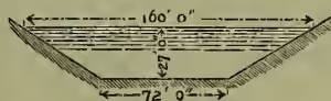
Suez Canal.—The canal cutting through the Isthmus of Suez, and thereby connecting the Mediterranean with the Red Sea, was commenced in 1860, and completed in 1869. The Suez Canal (q.v.) is about 100 miles long, and has a bottom width of 72 feet and a depth of 26 feet, with passing places at suitable intervals (fig. 1). The traffic, however, of the canal has so much increased, and the advantages of an increased draught for vessels has been so clearly established, that the canal is about to be widened to a bottom width of about 229½ feet, and deepened to 28 feet, and eventually to 29½ feet as shown by the dotted lines on the section.
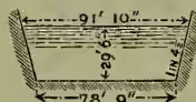
Panama Canal.—The route preferred by M. de Lesseps for connecting the Atlantic and Pacific Oceans by a canal across the Isthmus of Panama, was at about the narrowest part of the isthmus, between Aspinwall (Colon) and Panama, nearly along the line of the Panama Railway. The Panama Canal (q.v.) along this route, 47 miles long, was commenced in 1882. It was designed to be level throughout, like the Suez Canal, and to traverse the Culebra range in a cutting of 300 feet maximum depth; but the increased cost of the work, and the difficulty of raising additional capital, compelled Lesseps (q.v.) to resort to a locked canal. Ultimately the whole scheme collapsed in bankruptcy and criminal prosecutions for bribery and misversation of funds. The canal was to be 72 feet wide at the bottom, with side slopes of about 1½ to 1, and a depth of water of 27 feet (fig. 2),
except through the rock cutting of the Culebra, where the depth and width were to be increased as shown on the section (fig. 3).
Nicaragua Canal.—Another scheme for crossing the Isthmus of Panama by water, designed by an American engineer, and for which a concession was granted in 1887, and a company formed, consists in uniting Lake Nicaragua by a canal with the San Juan River, and thus with the Atlantic, and forming another portion of canal connecting the lake with the Pacific. This route will be 180 miles long; and it will be necessary to rise to the summit-level at or near the lake, which is to be effected by two or three locks, on either side, having each a lift of from 50 to 120 feet, and to improve the San Juan River. Harbours also will be required at either end; and as the mouth of the San Juan River, at Greytown, is liable to be exposed to accumulations of silt, it is proposed to place the harbour on the Atlantic side a little to the north.
Isthmus of Corinth Canal.—A canal was proposed across the Isthmus of Corinth long before the Christian era; and works for it were actually commenced in the reign of Nero, of which traces still remain. The canal, which shortens the distances between several of the ports of the Mediterranean and the Black Sea, was carried through at last, the works having been commenced in 1882. The canal is 4 miles long; and the central portion traverses a cutting in rock, of which the maximum depth will be 285 feet, the section of the canal at this part being shown on fig. 4. It is open throughout, with bottom width 72 feet, and its depth feet, like the original Suez Canal; and solid jetties have been built out into the sea for protecting the entrances at each end. The canal, opened in 1893, cost between £1,000,000 and £2,000,000.
Baltic Canal.—The Holstein Canal, 26 miles long, connecting the river Eider, which flows into the North Sea, with the Baltic, near Kiel, was opened in 1785, for enabling vessels of 120 tons to pass from the Baltic to the North Sea by a transit across Holstein of about 100 miles, saving the circuitous and difficult voyage round Jutland. As this canal is only feet wide at the bottom, and feet deep, it can only be traversed by small vessels; so the Baltic Canal (q.v.) has been made (1887-95) for enabling large sea-going vessels to take a short cut, saving 237 miles, between the Baltic and North seas, by traversing Holstein. The canal starts from Holtenau on the Baltic, near Kiel, where a great lock was constructed, and using a portion of the Eider, joins the Elbe at Brunsbüttel; its length is 60 miles, bottom width 85 feet, depth 28 feet, water-level same as the Baltic, greatest depth of cutting 100 feet, and cost about £8,000,000.
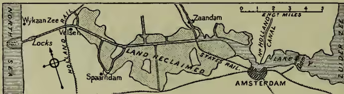
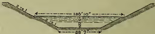
Amsterdam Ship-canal.—Though the canal connecting Amsterdam with the North Sea, severs the peninsula of North Holland, and unites the Zuider-Zee with the North Sea, its object was to afford more direct outlet for the trade of Amsterdam to the ocean than the shallow Zuider-Zee and the North Holland Canal could give, as this trade was being seriously imperilled by the better access to the sea possessed by Rotterdam and Antwerp. The direct route lay through Lake Y and Wyker Meer, so that only a narrow neck of dry land, 3 miles wide and of small elevation, had to be excavated between Velsen and the North Sea; and the reclamation of these lakes, by banks formed along the canal by dredged material raised from the bottom for deepening, defrayed a portion of the cost of the work (fig. 5). The canal is suited for sea- going vessels of large size, being wider at the base (fig. 6), and only 3 feet shallower than the original Suez Canal section; its length is miles. Locks near each end of the canal, with gates pointing both ways, give perfect control over the water-level of the canal, which is kept only 14 inches above low-water in the North Sea to maintain the drainage of the reclaimed lands, and the adjacent low-lying lands which formerly drained into the lakes. The drainage water which flows in from the branch canals, and is also pumped into the canal from the reclaimed lands, is lifted from the canal, and discharged into the Zuider-Zee, by pumps adjoining the locks situated in the dam which shuts off the Zuider-Zee from the canal and the reclaimed lands. Two converging concrete breakwaters protect the entrance channel, which has been dredged through the shallow sandy foreshore of the North
Sea coast. The works were commenced in 1865, and completed in 1876, at a cost of about £2,600,000; and the canal has proved of great benefit to the trade of Amsterdam.
Ghent-Terneuzen Canal.—The access to Ghent by the river Scheldt is so circuitous that various ways have been resorted to, since 1251, to give Ghent more direct communication with the sea. As the earlier, partially natural, routes had silted up, a new outlet was provided by a canal joining the estuary of the Scheldt at Terneuzen, completed in 1827; this route being only 21 miles, as compared with 105 miles along the Scheldt. As this canal had become inadequate for the present class of vessels, it was enlarged and deepened in 1870-85, being given an available depth of feet, which can be easily increased to 22 feet, and a bottom width of feet, with side slopes of 3 to 1; so that now vessels of from 1400 to 1700 tons can go up to Ghent.
St Petersburg and Cronstadt Ship-canal.—A canal was commenced in 1877, and completed in 1884, for enabling sea-going vessels to reach St Petersburg, which the bar at the mouth of the Neva, and the want of depth in the Gulf of Finland as far as Cronstadt, a distance of miles, had previously prevented. The canal starts from the Neva at St Petersburg, and after going south-west for about 2 miles, it curves round, and proceeds in a straight line north-west to Cronstadt. It is 22 feet deep throughout; it has a bottom width of 207 feet for the first portion, enlarging to 275 feet; and its embankments terminate 10 miles from Cronstadt, whence it proceeds in an open channel dredged through the Gulf. The total cost of the work was about £1,240,000.
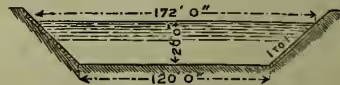
Manchester Ship-canal.—The scheme for connecting Manchester with the sea, by a canal from Manchester to the Mersey estuary, which excited vehement opposition from the Liverpool and railway interests during three sessions, was finally authorised by parliament in 1885. The canal starts in deep water at Eastham, on the left bank of the Mersey, above Liverpool, and nearly opposite Garston; and after skirting the shore of the estuary up to Runcorn, it cuts into the land, and following approximately the course of the Irwell higher up, it terminates at Trafford Bridge in Manchester. The Manchester and Salford docks are 105 acres in extent. The canal is miles long; its minimum depth is 26 ft., and its minimum bottom width 120 feet, with slopes of 1 to 1 in good ground (fig. 7), well pitched with stones to secure them against erosion by wash. The tidal locks at Eastham have their sills 20 feet below low-water, so that vessels are able to enter and leave the canal at about half- tide; and the lift of these locks is feet. The canal is divided into four reaches, 21 miles, , , and 3 miles long, between Eastham and Trafford Bridge, by locks at Latchford, Irlam, and Barton, with lifts of feet, 14, and 14 feet respectively (see the map at MANCHESTER). There are three sets of locks at each place, 550 feet long by 60 feet wide, 300 feet by 40 feet, and 100 feet by 20 feet, with intermediate gates in the two larger locks, to accommodate a great variety of vessels. The passage of the canal is about seven hours, making allowance of from 25 to 35 minutes for passing the locks. The cost of the canal, which was constructed between 1887 and 1894, was estimated at £5,330,000, but really amounted to £15,500,000. The Bridgewater Canal is carried over the ship-canal in a swing aqueduct, which is opened for the passage of masted vessels along the ship-canal; and a hydraulic lift affords communication between the two canals.
Various Ship-canal Schemes.—Several other schemes, besides the works referred to above, have been proposed. Thus a ship-canal across the projecting peninsula of Florida has been contemplated; schemes have been brought forward for enabling sea-going vessels to reach Paris and Brussels; and a plan was proposed in 1887 for improving the waterways between Birmingham and the Bristol Channel, at a cost of £1,890,000, to enable vessels of 200 tons to get up to Birmingham. A design has also been worked out for shortening the route to the east coast of India, by about 350 miles, by cutting through the island of Rameswaram, and thus making a navigable channel between Ceylon and India, through the Gulf of Manaar and the Palk Straits, at a cost of about £1,000,000.
A company was started in 1888 for the construction of a canal through the Isthmus of Perekop (q.v.), which connects the Crimea with the mainland of Russia. This canal will connect the Sea of Azov at the Don basin, with the north-western part of the Black Sea and the Dnieper basin. This Black Sea and Azov Canal is to be made 14 feet deep; but its construction has meantime been delayed.
A scheme for forming another junction between the Mediterranean and Red seas, consists in cutting a canal, 25 miles long, from Haifa, in the Bay of Acre, through the plain of Esdraelon, to the Jordan valley, and another canal, 20 miles long, from the Gulf of Akabah towards the Dead Sea into the Araba defile, whereby the waters of the Red Sea would flow into the depression of the Dead Sea, 1308 feet below the level of the Mediterranean, flooding this hollow and the Jordan valley. A vast inland lake would thus be formed, on which vessels could steam at full speed without the hindrances of the narrow Suez Canal. But the elevation of the land between the Red Sea and the Dead Sea is so great as to render this scheme almost impossible.
Another scheme aims at flooding a vast depression in the African desert, south of Algeria and Tunis, by cutting a canal from the Mediterranean, which would be enlarged by natural scour, and thus create an inland sea, 3160 sq. m. in extent, which would transform the climate of the adjacent lands, and afford them easy access to the sea.
These proposals show that the resources of canal enterprise are far from being exhausted; and that though railways have, for a time, affected the prosperity of small canals, the advantages of inland water-communication are becoming more clearly recognised, and the great value of ship-canals for sea-going trade has been firmly established.
THE CANAL-BOATS ACTS, 1877 and 1884, provide for the proper sanitary condition of canal-boats when used as dwellings. These acts also contain provision for the registration of such vessels by the local sanitary authorities through whose districts the boats ply; such boats being officially numbered and marked in a conspicuous place. Power is also given to fix the number, age, and sex of persons permitted to dwell in a boat. The local sanitary authority has the power, in the case of infectious diseases, of enforcing the Public Health Act of 1875. The education of children residing in these registered boats is assumed by the Elementary Education Acts to be as if residing in the place of registration, unless actually attending a school. Canal companies are empowered to establish schools for canal children. Masters and owners who do not satisfy the requirements of the Canal-boats Acts are liable to fines recoverable on summary conviction before two justices. The Local Government Board and also the Education Department must report each year to parliament on the execution of these acts—the former being also compelled to appoint inspectors, who are invested with powers similar to those of the Poor-law inspectors, to see that the provisions of the Canal-boats Acts are duly carried out.