Continent. This name, originally applied to a great division of the earth's surface containing a number of countries, has latterly come to have a more precise scientific meaning. Six continents are recognised by geographers—Asia and Europe (which, strictly speaking, form but one continent, the division between the two being arbitrary and uncertain); the three great triangular peninsulas, Africa, North America, South America; and the vast islands Australia and Antarctica. Antarctica has never been explored, but the evidence of the gradual shoaling of the sea on all sides within the Antarctic circle, and the nature of the rocks dredged in the far south, make the existence of a continent and not an archipelago of oceanic islands round the south pole practically certain.
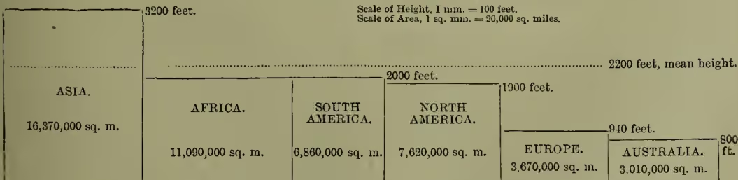
The earth's surface is divided by the 1000 fathom (6000 feet) line of ocean soundings into two equal parts, one a region of depression surrounding the south pole and stretching northward in three wide branches or ocean-basins, the other a region of elevation surrounding the north pole and stretching southward in three great arms crowned by the continents. All the land rising above sea-level forms collectively the continental area, and amounts to of the earth's surface. Geological evidence shows the extreme probability that the continental and abyssal areas have never changed places, but are permanent features of the earth's surface. Continental rocks, granite, gneiss, schist, and their derivatives, differ entirely from those of oceanic islands. Detached portions of the continents, though now far from the mainland, may therefore be readily recognised (see ISLANDS). Around all continents the action of waves has carved out a ledge or terrace, the continental shelf, of variable width, on which the bottom slopes gently from the land to soundings of 100 fathoms, and then abruptly plunges to the oceanic depression (see SEA). The absolute elevation of continents or mountains above mean sea-level cannot easily be determined, on account of the permanent distortion of the sea surface by the attraction of the projecting mass of land. This heaping up of the sea has been calculated at 300 feet for the vicinity of the Himalayas at the Bay of Bengal, and 2000 feet for the Chilian Andes. Sir John Murray calculates the average height of continental land above sea-level as 2200 feet, and gives as probable estimates the mean heights represented in the diagram. Particulars of each of these continents will be found under their respective names.
The continents occur in north and south pairs, united by a narrow isthmus or archipelago, or separated only by a shallow strait. They are directed south-south-eastward, tapering from the north in all cases, and frequently ending in a series of south-pointing peninsulas, which are often partially submerged so as to form archipelagos of small islands on the eastern side. Each continent has an axis or backbone of high land, usually a plateau containing an area of internal drainage, and serving as a watershed for rivers flowing to all sides. This high land is situated towards the south, and runs east and west on the whole in Eurasia, giving the north-flowing rivers long slopes, and the south-flowing streams a short and rapid run. Africa is a transition type, the watershed being on the whole nearer the east; Australia, more extreme, has the main watershed lying close to the east coast. In the two Americas there is a high western mountain-ridge or plateau running from north-west to south-east, and a low range on the eastern coast, leaving great central low plains watered by large rivers. The interior of a continent has usually a very low rainfall (see DESERT), and is subject to great extremes of temperature between summer and winter, and between day and night, hence the term continental climate. Land and sea breezes and the Monsoons (q.v.) of tropical coasts result from this circumstance.