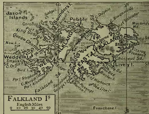
Falkland Islands, a British colony in the South Atlantic, lying between 51° and 53° S. lat. and 57° and 62° W. long., some 250 miles E. of Patagonia, with which they are geologically connected by a submarine plateau. The group consists of East Falkland and West Falkland, with about 100 small islands, besides the dependency of South Georgia (q.v.). According to the most reliable measurement—that of Wisotzki—East Falkland, with the neighbouring islands, has an area of 2849 sq. m., and West Falkland, with the small islands near it, an area of 1990 sq. m. Many of the islands are occupied only by myriads of penguins, whence the title King of the Penguins sometimes bestowed on the governor of the Falklands. Pop. (1871) 811; (1893) 1823. The shores are deeply indented with bays and inlets, containing many good harbours; the surface is for the most part undulating (Mount Adam, the highest point, 2315 feet), with numerous small streams and lakes; there are no trees, nor is coal found, but peat is plentiful. The climate is healthy, resembling that of the Orkneys, but is characterised by severe gales and abundance of moisture. The average annual temperature is about 34°; the average number of rainy days in the year is 240. Some wheat and flax are raised, but tussock grass and balsam bog are the principal vegetable products. The chief industry of the inhabitants is sheep-breeding. Wool, frozen meat, live sheep, tallow, skins, and hides are exported (principally to the United Kingdom). The exports rose from £20,000 in 1870 to £130,752 in 1891; the imports from £21,000 to £67,827. The capital of the colony is Stanley (pop. 700), originally founded as a port of refuge, on East Falkland. The group, first sighted by Davis in 1592, received its present name in 1689 from Captain Strong, in honour of his friend Lord Falkland. It was occupied by France in 1710 and 1764, when it was purchased for £30,000 by Spain, who immediately thereafter was compelled to surrender her claim on receiving the ultimatum of the British government. It was for a while evacuated, but was definitely occupied by Great Britain in 1833, and utilised as a penal colony until 1852.