Fiji. The Fiji or Viti Islands are a British dependency in the South Pacific Ocean, situated in — S. lat. and E.— W. long. Their nearest neighbours are the Tonga or Friendly Islands, between 200 and 300 miles to the south-east; they are about 700 miles from the French colony of New Caledonia, 1100 miles from Auckland in New Zealand, 1700 from Sydney in New South Wales, 1800 from Tahiti, and 4700 from the great American port of San Francisco. They have mail communication with Auckland once a month, and with Sydney on an average once a fortnight. The island of Rotumah, about 250 miles distant, a little to the west of north, has been since 1881 included in the colony.
The islands were sighted in 1643 by Tasman, the great Dutch sailor, whose name is borne by Tasmania. Turtle Island (or Vatoa), in the extreme south-east of the group, was discovered and so named by Captain Cook in 1773; but, like most of the South Sea islands, the Fiji Archipelago was little known before the 19th century. Since that date its history has been the not uncommon one of native dissensions, gradual European intrusion, and finally European protection. In 1804 some escaped prisoners from Australia are said to have settled in the islands. In 1835 Wesleyan advantages as a naval and coaling station and as a place for cotton-growing. On his advice the offer of sovereignty was in 1862 rejected. The following years brought a considerable increase to the white population of the islands, cotton-planting being stimulated by the American civil war. About 1868 a company was formed in Australia, under the name of the Polynesia Company, to take over Thakombau's debt, and with it the 200,000 acres referred to above. In 1871 a kind of constitutional government was set up by the European advisers of King Thakombau, but the cession of the islands to Great Britain was again pressed on, and, after further inquiry in 1873, Sir Hercules Robinson, then governor of New South Wales, was sent to Fiji, and on the 10th of October 1874 formally accepted the sovereignty of the group on behalf of the British crown.
Fiji was constituted and remains a crown colony, with a governor (who is also high-commissioner for the Western Pacific), an executive council, and a legislative council, composed, in addition to the governor, of six official and six nominated unofficial members. The natives are organised in village, district, and provincial councils (the colony being divided into fourteen provinces), and have a special system of taxes, paid mainly in kind.
The Fiji Islands, over 200 in number, lie in a ring, open on the southern side. The configuration of the group is not unlike that of the West Indies. On the west and north are the two large islands of Viti Levu and Vanna Levu, with a group of small islands and reefs outside them; and on the east there is a long string of islands of small size, answering to the Leeward and Windward groups in the West Indies.
The total area of the colony (including Rotumah) is given at 7435 sq. m., being about the same size as Wales. The area of Viti Levu is over 4000 sq. m., rather smaller than Jamaica, and the area of Vanna Levu is about 2400 sq. m. Since 1882 the capital of the colony has been Suva, on the south coast of Viti Levu, where there is a fine harbour; before that date Levuka, on the little island of Ovalau, off the east coast of Viti Levu, also possessing a good harbour, was the European capital. Municipalities have been established at both places.
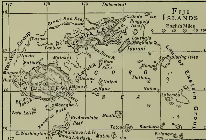
The Fiji Islands are of volcanic formation, the shape of the mountains (the highest of which rise to some 4500 feet) and the existence of hot springs testifying to volcanic agency; and they are surrounded by coral reefs, which act as natural breakwaters. They are singularly favoured by nature, being well supplied with harbours, and equally well with rivers, having an abundant water-supply, a rich soil, and a climate which, though tropical and somewhat enervating to Europeans (who are subject to dysentery), is not unhealthy or extreme. They suffer, however, from the ravages of hurricanes, and earthquakes occasionally occur. In 1887 at Suva the shade temperature varied from a maximum of in November and January to a minimum of in August, and the rainfall was about 100 inches. The rainfall is greatest and the land is most heavily timbered on the south-eastern—the windward—side of the islands; on the leeward side the face of the country is more that of open grass-land. With the exception of the bêche de mer and pearl-shell industries, the resources of Fiji are almost purely agricultural. In addition to the timber and fruit trees, the latter including missionaries first came over from Tonga to begin their wonderful work of conversion to Christianity; and trade, which had begun with dealings in such articles as bêche de mer and sandalwood, gradually led to a small white settlement.
In 1849 some damage was done to the property of the American consul; a heavy claim was in consequence preferred by the United States government against the leading chief Thakombau, which he was wholly unable to meet, and in 1858 he offered the sovereignty of the islands to Great Britain, on condition that he retained his rank and that his debt was paid. As a set-off to the payment he offered to make over, if required, to the British government the ownership in fee simple of 200,000 acres of land. Upon receipt of this offer a special commissioner, Colonel Smythe, was sent to Fiji, charged to report especially upon its prospec- bananas, bread-fruit, &c., and in addition to the cocoa-nut palms, the vegetable products of the islands include sugar, grown with the help of imported Indian and Polynesian labour, maize, cotton, tea, and coffee. There are hardly any indigenous animals in the islands, and but scanty signs of mineral wealth.
The population of Fiji in 1891 amounted to 121,180, of whom over 2000 were Europeans, and over 110,000 native Fijians. The native population is said to have been larger in former years, and was certainly reduced by the outbreak of measles in 1875. The death-rate among the natives is high, an average of some years showing a rate per 1000 nearly double that of England and Wales. They are in race akin to the Papuans, being the easternmost members of that family, but an admixture of the lighter Polynesians has been brought in from Tonga and elsewhere, and has, especially in the eastern islands of the group, leavened the native Melanesian breed. The Fijians were, prior to the introduction of Christianity, notoriously ferocious cannibals, but religious after their kind, and possessing a strong belief in a future life. At the present time the Christian religion is almost universal in the islands, the adherents of the Wesleyans being estimated at over 100,000, and of the Roman Catholics at more than 10,000. Education is mainly carried on in the mission schools, with the assistance of grants in aid from government; at Suva and Levuka there are school boards, and in Vanna Levu a government industrial school. The revenue, derived mainly from customs duties and native taxation, has not always covered the expenditure. In 1882 the revenue was £111,314; in 1887, £64,916; in 1894 (when the expenditure was £72,204), £80,054. Sugar, in spite of the depression of the industry, is far the most important export, and next to it in value come cocoa-nuts (mainly in the dried form known as copra), fruit, pea-nuts, cotton, and colonial spirits. In 1890-94 the value of imports (mainly drapery, machinery, hardware, coal, breadstuffs, meats, and rice) increased from £206,757 per annum to £285,981; the exports fluctuated from £364,533 to £581,652. The trade of the colony, both import and export, is almost entirely with New South Wales, New Zealand, and Victoria in the order given. Fiji has become British by the force of circumstances, and not on account of its natural advantages; but it has considerable agricultural resources, it is a station from which British influence can be exercised in the South Pacific, and its excellent harbours might possibly be more utilised in the event of the Panama Canal being successfully carried out, as the islands lie not very far out of the direct route between Australia and Central America.
A good short account of Fiji, with a map, is given in the annual Colonial Office List, and much information will be gained from a blue-book presented to parliament in 1862, which gives both Col. Smythe's Report on the islands (with maps) and also the very valuable 'Report on the Vegetable Productions and Resources of the Vitian or Fijian Islands,' by Dr Seeman, who accompanied Col. Smythe on his visit. Miss Gordon Cumming's At Home in Fiji (1881) is but one out of several books on the colony.