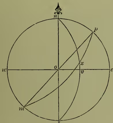
Great Circle or Tangent Sailing. In order to have a clear idea of the advantages of great circle sailing it is necessary to remember that the shortest distance between two places on the earth's surface is along an arc of a great circle (see SPHERE); for instance, the shortest distance between two places in the same latitude is not along the parallel of latitude, but along an arc of a circle whose plane would pass through the two places and the centre of the earth. The object, then, of great circle sailing is to determine what the course of a ship must be in order that it may coincide with a great circle of the earth, and thus render the distance sailed over the least possible. This problem may be solved in various ways. The handiest practical solution is to stretch a string over a terrestrial globe quite tight between the ports of departure and arrival. The string will lie on the great circle required. A few spots on the track of the string should be transferred to the ordinary navigating (i.e. Mercator's) chart, a free curve should be drawn through these transferred spots, and the ship should be kept as close to that curve as possible. The solution by computation is simply the calculation of sides and angles in a spherical triangle. The method by computation will be understood from the accompanying diagram, where are the poles of the earth, the equator: represents a meridian which passes through the place , another meridian through the place , and a portion of a great circle; let be the place sailed from, and the place sailed to, then is the great circle track, and it is required to determine the length of (called the distance), and the angles , , which are equal to the first and last true courses. To determine these we have three things given: , the co-latitude of ; , the co-latitude of ; and the angle , which, measured along , gives the difference of longitude. The problem thus becomes a simple case of spherical trigonometry, the way of solving which will be found in any of the ordinary treatises on the subject of Spherical Trigonometry.
Next, several longitudes on the route, say at intervals, are chosen, and the co-latitudes of the spots on the great circle which correspond to these assumed longitudes are calculated. The latitude and longitude of these spots on the great circle being now obtained, the courses and distances from one to the other in succession can be found by the ordinary processes of navigation. The work is somewhat shortened by finding that particular spot on the entire great circle which lies farthest from the equator. It is called the vertex, and is easily found by the property that the meridian running through it is at right angles to the great circle at that spot. To avoid these, or some of these somewhat troublesome calculations, charts have been constructed on projections different from that of Mercator. On one of these, called the Gnomonic Projection, all the great circles are straight lines; on another, all the great circles are true circles. It has also been suggested that the ports of departure and arrival being given, and the vertex (described above) having been found, and all three having been marked on a Mercator's chart, a true circle drawn through these three spots will be near enough to the great circle for practical purposes. A modification of this approximate method is useful in the run between the Cape of Good Hope and Australia, on which the great circle route goes too far into the southern ice-region. If a spot of highest safe south latitude be here substituted for the latitude of the vertex, a circle drawn through the places of departure, of arrival, and of the substituted safe vertex will give what is called a composite great circle.
From the theory of great circle sailing the following most prominent features are at once deduced: A ship sailing on a great circle makes direct for her port, and crosses the meridians at an angle which is always varying, whereas, by other sailings, the ship crosses all meridians at the same angle, or, in nautical phrase, her head is kept on the same point of the compass, and she never steers for the port direct till it is in sight, except in the two cases where the ordinary track lies (1) on a meridian, or (2) on the equator. As Mercator's Chart (see MAP) is the one used by navigators, and on it the course by the ordinary sailings is laid down as a straight line, it follows, from the previous observations, that the great circle track must be represented by a curve, and a little consideration will show that the latter must always lie in a higher latitude than the former. If the track is in the northern hemisphere it trends towards the north pole; if in the southern hemisphere it trends towards the south pole. This explains how a curve-line on the Mercator's chart represents a shorter track between two places than a straight line does; for the difference of latitude is the same for both tracks, and the great circle has the advantage of the shorter degrees of longitude measured on the higher circles of latitude. Consequently, the higher the latitude is the more do the tracks differ, especially if the two places are nearly on the same parallel. The point of maximum separation, as it may be called, is that point in the great circle which is farthest from the rhumb-line on Mercator's chart. Since the errors of dead-reckoning, or even of dead-reckoning supplemented by astronomical observation, prevent a ship from being kept for any length of time with certainty on a prescribed track, and thus may necessitate the calculation from time to time of a new path, in practice the accurate projection of a great circle track on the chart would be a waste of time. Some ignorantly object to great circle sailing on the ground that, on account of constant change of the course steered, a ship cannot be kept with absolute precision on the correct great circle track. But, in fact, all that is required of a navigator is to sail as near to his great circle track as convenient; and each separate course will be approximately a tangent to his track, and the shorter these tangents are made the more will the length of a voyage be diminished.