New Guinea, an island of Australasia, the largest in the world except the Australian continent, from which it is separated by the shallow island-studded Torres Strait, 80 to 90 miles wide at its narrowest part, about the meridian of the York Peninsula. There is now no doubt that the two regions at one time, probably during the Miocene epoch, formed continuous land, and an upheaval of less than sixty fathoms would suffice again to unite them. The hundred-fathom line, as determined by Wallace, would also include the insular groups of Jobi, Biak, Suk, Mafor
(Nufor), and Amberpoca in Geelvink Bay; Aru, near the south-west coast; Mysol, Salwatty, Batanta, and Waiju at the north-western, and the Louisiade and D'Entrecasteaux Archipelagoes at the south-eastern extremity of New Guinea. But elsewhere the mainland is washed by deep waters, ranging from 500 to 1300 fathoms on the south-eastern and northern seaboard. It is disposed in the direction from north-west to south-east, stretching from Cape Goede Hoop ('Good Hope'), just south of the equator ( and ), for about 1500 miles to South Cape, over 700 miles below the equator ( and ). But owing to its extremely irregular shape, somewhat resembling a huge saurian, the width varies from under 20 miles at the narrowest parts of both extremities to 480 miles at the broadest part, about long, giving a total area roughly estimated at 320,000 sq. m., or six times as large as England. The island thus forms three somewhat distinct geographical divisions—a large central mass from which two peninsulas project south-east and north-west. The south-east peninsula is defined by Huon and Papua Gulfs on the north and south coasts, while the north-west peninsula is decomposed into two secondary members by the Maccher Inlet, which penetrates from the south-west side to within 20 miles of Geelvink Bay on the north-west coast.
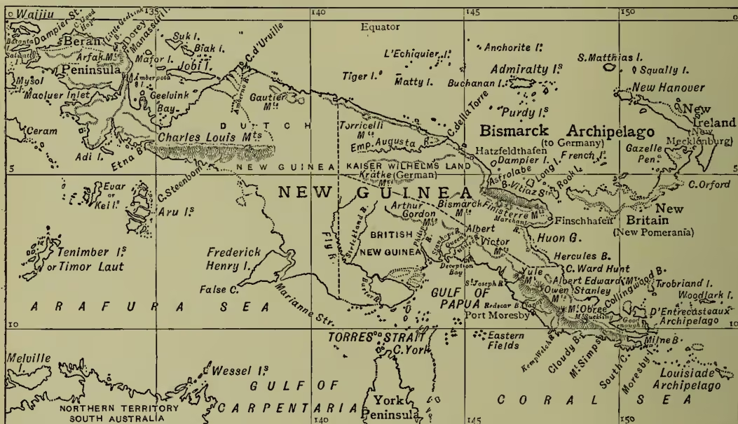
Most of the interior is still a terra incognita; but the more salient physical features of the island have already been roughly determined. It is essentially a mountainous and even an alpine region, being traversed in its entire length by lofty ranges, by far the highest in the Oceanic world, and in some places rising 2000 or 3000 feet above the snow-line. These ranges, which in the two peninsular regions form single continuous systems, develop in the broader central parts two or more parallel chains with a general south-easterly trend, at many points approaching close to the coast-line, and elsewhere enclosing extensive rugged plateaus. Thus, the Arfak Hills of the north-west peninsula (10,000 feet) are continued in the central region by the Charles-Louis range, which for nearly 300 miles appears to maintain an altitude of over 14,000 feet, with many peaks towering to heights of 18,000 and even 20,000 feet. Parallel with this chain runs the northern coast range, known as the Finisterre Mountains (11,500 feet), which terminate eastwards in an imposing headland projecting in the direction of New Britain, and enclosing Huon Gulf on the north side. Between these two chains run the Bismarck and Krätke ranges (10,000 feet), the latter discovered in 1887 by Dr H. Zöller. About the same time Count Pfeil, administrator of German New Guinea, penetrated from the north coast still farther inland in search of expansive table-lands suitable for settlement; but he found the whole surface broken into a confused mass of steep mountains composed mostly of old sedimentary rocks—altogether 'a rugged, hopeless region' intersected by deep gorges, but few open river-valleys.
All these mountain-ranges converge in the south-east peninsula in a single lofty chain which traverses the whole of British New Guinea, but the various sections of which take the names of the Albert Victor, Yule, Owen Stanley, and Lorne ranges, in their order from west to east. But the nomenclature is still far from settled, and much confusion has been caused by recent travellers renaming peaks and crests and even rivers already determined by previous explorers. The prevailing formations appear to be very old plutonic and sedimentary rocks. Gneiss and granites crop out in the Arfak highlands; elsewhere stratified clay-slates and old limestones abound, containing shells identical with those of south-east Australia; quartz and greenstones occur on the south-east coast resembling those of the auriferous region in New South Wales, and there are numerous other indications of the presence of gold in many districts. Earthquakes are frequent in some places, but no active volcanoes appear to exist, although there are several comparatively recent craters on the spurs of the Owen Stanley range, while pumice and scoriae cover the flanks of the Finisterre Mountains.
One result of the explorations has been the discovery of a surprising number of considerable rivers in every part of New Guinea. The three largest appear to be the Amberno (Mamberan, or 'Great River') in Dutch, the Empress Augusta in German, and the Fly in British territory. The Amberno (the Rochussen of Dutch geographers) descends from the Charles-Louis range to the east side of Geelvink Bay, where it develops an extensive delta. The Empress Augusta flows from the unexplored central water-parting north-eastwards to the coast at Cape della Torre in S. and E., entering the sea in a broad, deep channel without any delta. In the rainy season it is navigable for many miles by large vessels, and both the main stream and several tributaries are accessible for a long way to river-steamers. But the largest of all New Guinea rivers is certainly the Fly, which rises on the southern slope of the central water-parting and flows mainly south-east to a delta of vast extent on the west side of the Gulf of Papua. The Baxter (Mia Kasa), which enters the sea farther west, opposite Cape York, is an independent stream unconnected with the Fly. This great estuary, which was discovered in 1845 by Blackwood and named after his vessel the Fly, was ascended in 1876 by D'Albertis for 500 miles in a steam-launch, and again in 1889 for over 600 miles by Sir W. Macgregor. The tides ascend the Fly for 150 miles, and 90 miles higher up it is joined on its left bank by the Strickland. Farther east several other copious streams flowing from the main range through British territory to the Gulf of Papua have also been either recently discovered or for the first time surveyed. Such are the Douglas, Centenary, Stanhope, and Queen's Jubilee, all of which converge in an almost continuous common delta about the head of the Gulf. But here again the terminology is much confused, the Douglas and Jubilee being respectively Blackwood's Aird and the already partly-surveyed Aivei. Mr Bevan's Philip also is merely the upper course of the Aird, of which the Centenary appears to be an eastern and the Newbery a western branch. The east side of Papua Gulf is joined by other navigable streams from the Owen Stanley range, the more important of which are the St Joseph, flowing from Mount Yule to Hall Sound; the Vanapa, draining the southern slopes to Redscar Bay, and followed by Sir W. Macgregor on his expedition to Mount Victoria (Owen Stanley) in 1889; the Kemp Welch, flowing to Hood Bay; and the Davadava and Hadava, reaching the coast at Milne Bay. In German territory also, besides the Empress Augusta, no less than nine new rivers have recently been discovered, one of which, the Markham, gives easy access a long way into the interior.
The whole of New Guinea lies within the track of the south-east trade-winds, which prevail from March to October, and which are charged with much moisture from the Pacific. These are followed for the rest of the year by the north-west monsoons, whose rain-bearing clouds are condensed on the cold alpine slopes of the island. The consequence is that the rain or snow fall is considerable in every part of the country, and this, combined with an average high temperature of from to F., results in a hot, moist climate on all the low-lying coast-lands and fluvial valleys. So excessive is the moisture in some places that 'boots put aside for a day or two grow a crop of mildew nearly half an inch in thickness' (Guillemand). Hence fever is endemic, not only in the lowlands, but to a considerable height above sea-level, the malarious exhalations being carried upwards by the atmospheric currents, as on the Central African plateaus. At the same time its action is most capricious, and its true character still but little understood. 'It may be very troublesome where weather, soil, and other conditions should be favourable to health, and perhaps almost absent under the opposite conditions' (Coutts Trotter). Exactly similar phenomena have been observed in tropical Africa, and it may be inferred that New Guinea, as a whole, is as unsuitable as that continent for European settlement. But some of the uplands beyond the fever zone may be found adapted, if not for permanent colonisation, at least for the establishment of health-resorts for officials, traders, and missionaries.
Thanks to its abundant rainfall, varying altitudes, high temperature, and position intermediate between the Asiatic and Australian botanical areas, New Guinea is almost everywhere clothed with a rich and highly diversified flora. The vegetable zones appear to be even superimposed as in Mexico, and Sir W. Macgregor's party, after passing successively through the domains of tropical plants, such as the cocoa-nut, sago, banana, mango, taro, and sugar-cane, and of such temperate or subtropical growths as the cedar, oak, fig, acacia, pine, and tree-fern, were gladdened on the higher slopes by the sight of the wild strawberry, forget-me-not, daisy, buttercup, and other familiar British plants. Towards the summits these were succeeded by a true Alpine flora, in which Himalayan, Bornean (Kinibalu), New Zealand, and subantarctic forms were all numerously represented. In general, arboreal vegetation ceases at about 11,000 feet, and shrubs at 12,000, the latter being overlapped by the Alpine zone. In New Guinea the Asiatic and Malayan floras are far more richly represented than the Australian, as shown by the absence or rarity of the eucalyptus, of which as many as fifty varieties are found in the southern continent. Indigenous forms are numerous, and include many species of palm.
On the other hand, the New Guinea fauna is much more closely related to that of the Austral than to that of the northern hemisphere. This is seen in the almost total absence of placental mammals and the presence of over thirty species of marsupials, such as the cuscus and kangaroo, as well as the bower-bird, of which two new species were discovered on the Owen Stanley range. Here also were found the European lark and black-bird in curious association with the bird of Paradise, of which typical New Guinea bird many varieties occur. Scarcely any birds of prey are found, a circumstance which may explain the presence of so many forms—parrots, cockatoos, pigeons, &c.—remarkable for their gorgeous plumage. Reptiles are numerous, and include a remarkable python (Chondropython pulcher), intermediate between the Asiatic python and American boa. A still more remarkable intermediate form, supplying a link between reptiles and mammals, is the spiny ant-eater, which is allied to the Australian echidna, and like it oviparous. There are three species of this ant-eater, while the placental mammals are represented only by some bats and mice, besides the pig and dingo, both probably introduced in comparatively recent times.
Man also would seem to have invaded the island after its separation from Australia, for the inhabitants of the two regions belong to fundamentally distinct stocks. Between the Australians and Papuans, who form the great bulk of the New Guinea population, there is little in common except the dark colour, considerably darker, however, in the latter than in the former. But the New Guinea natives are far from a homogeneous people, and the descriptions of travellers in different parts of the island differ so greatly that many anthropologists have doubted or even denied the existence of any Papuan type. These discrepancies are due to the presence and intermingling of at least four ethnical elements: Papuan proper, diffused over the whole region; Negrilo (Karons and others in the north-west peninsula and probably also in the central highlands); Eastern Polynesian, such as the Motu of the south-east coast; lastly, Malay, along the north-western seaboard and around the shores of
Geelvink Bay. The mingling of these elements in different proportions has brought about much diversity in the physical appearance, speech, usages, and general culture of the natives, who are everywhere broken into small tribal groups speaking a surprising number of distinct languages, some of which are members of the widespread Malayo-Polynesian family, while others, especially in the interior, seem to have no connection with that or any other known forms of speech. The tribal organisation is extremely loose, hereditary rulers being nowhere recognised, and the so-called chiefs depending for their prestige either on personal, social, or religious influences (S. Forbes). Cannibalism is very prevalent, though by no means universal; and some tribes, such as the Togaris of the south coast, are predatory, living entirely by plundering expeditions amongst the surrounding populations. But many others are peaceful, industrious, and keen traders, displaying remarkable skill, especially in the arts of pottery, wood-carving, and husbandry.
New Guinea appears to have been first sighted by A. D'Abreu in 1511, and first visited by De Meneses about 1526, and Alvaro de Saaverda in 1528. It received its present name in 1546 from Ortiz de Retez (Roda), who was struck by the resemblance of its inhabitants to those of the Guinea coast in West Africa. During the flourishing period of the empire of Tidor, the Malay sultans of that state extended their sway over the so-called Raja Ampat or 'Four Kingdoms' of Waijiu, Salwatty, Mysol, and Waigamma, including large tracts on the adjacent mainland. In 1793 the East India Company occupied the island of Manassari in Geelvink Bay; but the British troops were soon withdrawn, and in 1814 the English government admitted the claims of Holland to the Raja Ampat as suzerain of the sultan of Tidor. In 1848 the Dutch proclaimed their sovereignty over the western half of the island as far as 141° E. long., and this meridian was accordingly taken as the western boundary of the eastern half in 1884, when that section was divided between Great Britain and Germany. The boundary between the northern and German and the southern or British division coincides with the crest of the main water-parting. Subjoined is a roughly estimated table of the areas and populations of the territories assigned to these three states:
| Area in sq. miles. | Population. | |
|---|---|---|
| Dutch New Guinea..... | 158,000 | 200,000 |
| British " ..... | 90,000 | 135,000 |
| German " ..... | 70,000 | 100,000 |
| Total..... | 318,000 | 435,000 |
In the Dutch section, which is attached to the Residency of Ternate, there are no towns or administrative centres, Dorey, at the north-west side of Geelvink Bay, being merely a missionary station chiefly noted as the starting-point of many expeditions to the interior. No effort has ever been made by the Dutch government or by private enterprise to develop the resources of the country. German New Guinea, officially known as Kaiser Wilhelm's Land, is a protectorate administered by the German New Guinea Company, which has stations at Astrolabe Bay, Finschhafen, Konstantinhafen, and Hatzfeldhafen. It yields for export tobacco, areca, sago, bamboo, ebony, and other woods. British New Guinea, which includes the D'Entrecasteaux and Louisiade Archipelagos, was administered as a protectorate by a Commissioner till 1888, when the sovereignty of the Queen was proclaimed, the government being placed under Sir William Macgregor as administrator. New South Wales, Victoria, and Queensland each contribute £5000 towards the expenses of administration. The territory is divided into a western, central, and eastern division, under deputy-commissioners, the chief station being Port Moresby. The revenue already exceeds the expenditure, and the exports, chiefly gold, pearl-shells, bêche-de-mer, and copra, exceeded £24,000 in 1889.
See works on New Guinea and accounts of voyages thither by Th. Forrest (1774-76), Modera (Dutch, 1830) in the Journ. Roy. Geog. Soc. xxviii., Dunont d'Urville (1839), Marsden in Trans. Roy. Asiatic Soc. 1831, G. W. Earl (1835) in Logan's Journal, vi. (1852), J. MacGillivray (1850), O. Finsch (German, 1865), Miklukho Maclay (in Petermann, 1873), Rev. Wyatt Gill (1874), Moresby (1876 and 1877), Octavius Stone (1880), Lawer (1880 and 1883), D'Albertis (1880), Powell in Proc. Roy. Geog. Soc. 1883, Coutts Trotter in the same, 1883, 1884, and 1890, Prince Roland Bonaparte in the Bulletin of the French Geog. Soc. 1884, Rye (bibliography of over 1000 entries) in supplementary papers of the Roy. Geog. Soc. 1884, Rev. J. Chalmers (1885 and 1887), Ch. Lyne (1886), Romilly (1886 and 1889), Forbes in Scot. Geog. Mag. 1888, Macgregor in Proc. Roy. Geog. Soc. 1890, Bevan (1890); besides Wallace's Malay Archipelago (1869), Keane's Eastern Geography (1887), Thomson's British New Guinea (1892), and Guilleminard's Malaysia and Polynesia (1895).