Polar Exploration. In scientific geography much of the best work done in the 19th century is due to discoveries made in the Arctic and Antarctic regions. In the former, more especially, not only have new lands been surveyed, but large and important accessions have been made to several branches of natural science. The original motive, however, in England at least, for exploring the Arctic seacoasts was to discover a route to the wealthy countries of eastern Asia, and to share in the traffic monopolised by Spain and Portugal when at the height of their power. Thus arose a double series of attempts, either to coast eastward along the north of Europe and Asia, or to sail westward across the Atlantic; the latter being afterwards modified into attempts to coast westward along the north of America. Hence arose the terms 'North-east Passage' and 'North-west Passage.'
Some have traced the history of Arctic exploration to the time of King Alfred, who, in his translation of Orosius (q.v.), inserted an account of the voyages of Othhere and Wulfstan, narrated to him by Othhere himself, who seems to have sailed round the North Cape to Lapland. The voyages of the Norsemen to Greenland (q.v.) and the opposite coasts of America in the 10th and following centuries may be regarded as to some extent coming within early Arctic attempts. Cabot's discovery in 1497 of Newfoundland and Labrador might, however, be termed the first step in the exploration of American polar regions—for the earlier expeditions claimed on behalf of Portugal must be regarded as mythical. Three years after Cabot, Gaspar Cortereal and his brother made three separate voyages in the same direction, sailing northwards by Labrador, where they were stopped in 60° N. lat. The expedition commanded in 1553 by Sir Hugh Willoughby led the way to the North-east Passage. Willoughby sighted Nova Zembla, but he and his men ultimately perished on the coast of Lapland. Chancellor, who accompanied him, landed in Russia near Archangel. Other Englishmen followed, Burroughs (1556), Pet and Jackman (1580), Henry Hudson (1608-9), Wood (1676), but none succeeded in getting much beyond Nova Zembla, though they did good work in exploring the north coast of Europe, Spitzbergen, and other islands in these seas. In 1594-97 Barentz, a Dutchman, led three expeditions, wintering on the north-east coast of Nova Zembla, 1596-97 (see BARENTZ). After the failures of Hudson and Wood in the 17th century, the attempt to sail eastwards came to be considered quite hopeless. In 1607 Hudson succeeded in reaching 81° 30' N. in the neighbourhood of Spitzbergen.
Meanwhile some exploration of the Arctic parts of America had been going on. Frobisher first sailed in 1576, and in 1585-88 the great navigator Davis sailed up the strait bearing his name to 72° 41' N. and coasted the west of Greenland, 'the land of desolation.' In a tract of Davis', published in 1595, there are arguments for a North-west Passage. Hudson, who had tried the North-east Passage, discovered in 1610 the strait and great bay which bear his name. From the size of the latter he concluded it to be part of the Pacific; but that was disproved by Button, the next English explorer (1612). In 1615-16 Baffin, who went out at first under Bylot, had had some scientific training, proved himself as skilful a navigator as Davis. He found the great northern outlet to Baffin Bay, and recorded some important magnetic observations. After the expedition of Fox and James in 1631, which only led to the partial exploration of what then was named Fox Channel, the North American coast was neglected for more than a century.
Russia was naturally interested in the exploration of the Siberian coast, and from Peter the Great's time took her proper share in the maritime discovery. Behring, after receiving instructions from Czar Peter on his death-bed, sailed from Okhotsk, and discovered the straits which bear his name. In a second voyage (1741) he sailed from Petropaulovski and explored part of north-west America. Another Russian expedition in 1742 found (but did not succeed in rounding) the most northerly point of Siberia, named from the discoverer Chelyuskin (or Severo); and an earlier one sailed from the Yenisei to 75° 15' N. In 1765 Tschitsakoff sailed to Spitzbergen, and finally reached 80½° N. The New Siberian Islands were explored by Hedenström in 1809-11, by Anjou in 1823, and in 1884-87 by Bunge and Toll. Wrangel explored the Siberian coast between Cape Chelagskoi and the Kolyma in 1820-23, and in 1843 Middendorff laid down the unvisited coast in the neighbourhood of Cape Chelyuskin. In the reign of George III. there was a new revival of English zeal in naval adventure. Captain Phipps (afterwards Lord Milgrave) sailed in June 1773 to Spitzbergen, where the heavy pack-ice kept him nearly a month from proceeding farther north. Finally he reached 80° 48' N., and Cook, who next made the attempt, could only penetrate to . The government offered a prize of £5000 to any crew that should reach N. long.; but after those failures there was no effort made till 1806, when Scoresby reached N. immediately above Spitzbergen. In following expeditions Scoresby explored Jan Mayen Island and the east coast of Greenland, largely adding to our knowledge of the physical geography and natural history of the Arctic regions. The expeditions of Buchan and Franklin in 1818, of Cluvering in 1823, of Graah in 1828, of De Blossé- ville in 1833, did not reach higher latitudes than those which preceded them.
To encourage polar exploration on the North American coast the British government had promised a reward of £20,000; yet nothing was done till the Admiralty in 1818 sent out Ross and Parry, who only explored part of Lancaster Sound. Next year Parry alone discovered Prince Regent Inlet, Barrow Strait, and ( W.) Melville Sound. Following up this line of exploration, Ross in 1829 at last reached a point only 200 miles from Turnagain
Point, which had recently been found by another expedition sailing eastward from Behring Strait. Ross then named Boothia Felix, in which the magnetic pole lay, and King William's Island. In 1826-27 Franklin traced the North American coast from the Mackenzie River westwards to Cape Beechey, 860 miles, while his companions, Richardson and Kendall, proceeded eastwards towards the Coppermine River. Dease and Simpson in 1838 extended the survey of the American coast for about 100 miles, from Point Turnagain. In 1846-47 Dr John Rae explored the west shore of Boothia Gulf, and discovered Boothia Felix to be a peninsula. In 1851 the same explorer surveyed the coast from the Mackenzie River to King William Land, and also the south-east coast of Victoria Land.
The success of Ross led to Sir John Franklin's expedition (left England May 19, 1845), so unfortunate to him and his crew, so famous from the number of search-parties which it occasioned. His object was to penetrate to Behring Strait from Lancaster Sound (see FRANKLIN, SIR JOHN). In N. lat., W. long., on the west side of King William's Land, the ships were beset, and Franklin died June 1847. The survivors abandoned the ships, and all perished. Many search-expeditions were sent out. One of these, under Collinson and M'Clure, sailed from Plymouth to Behring Strait in 1850. Fixed in the ice on its eastward voyage, M'Clure's ship was rescued next spring by Sir Edward Belcher, about 60 miles west of Barrow Strait. Belcher now returned towards the Atlantic, and thus M'Clure with his crew reached England in 1854 after actually traversing the North-west Passage from ocean to ocean. He therefore received the honour of knighthood, and a sum of £10,000 was voted by parliament to him and the crew. One of the last search-expeditions was that in the Fox, under Captain (now Sir) Leopold M'Clintock, sent out by Lady Franklin in 1857. M'Clintock obtained many relics from the
Eskimo of Boothia, and in a cairn in Point Victory found the record which told the story of the expedition. Perhaps we should here note the fact that afterwards, 1879-80, one of the United States search-expeditions, under Lieutenant Schwatka, found evidence that Franklin had really completed the discovery of the North-west Passage. Owing to the different Franklin expeditions from Great Britain and the United States the whole Arctic coast of North America was explored almost ex- haustively, so that several routes are now completely mapped between Davis Strait and Behring Strait. For commercial purposes, however, the North-west Passage is of no value whatever.
And now to return to the North-east Passage. In 1827 Parry sailed to Spitzbergen, and after much toilsome effort reached N. After that little was done in this region till Sweden began to take an active interest in the exploration, under the active guidance of Professor (afterwards Baron)
Nordenskiöld, who in 1858-72 did much exploring work in the Spitzbergen islands and seas. In two voyages he reached the Gulf of Obi. At last, in 1878, he rounded Cape Chelyuskin, , and after wintering near Behring Strait sailed into the Pacific and reached Yokohama, 2d September 1879. Thus, three and a quarter centuries after the attempt of Willoughby, the North-east Passage was at last completed. Before that date an Austrian expedition under Lieutenants Payer and Weyprecht had been singularly successful, having discovered an island about 200 miles north of Nova Zembla, as large apparently as Spitzbergen. This new country, Franz-Josef Land, extends from to about . At a later date (1880) this land was still farther explored to the north-west by Mr Leigh Smith; and in the winter of 1881-82 Mr Leigh Smith wintered at Franz-Josef Land, he and his companions having great difficulty in escaping.
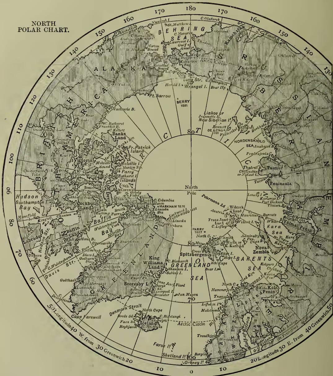
The more recent exploration to the north of America has added little to our geographical knowledge, however interesting in certain scientific aspects. The expedition of Kane and Hayes in 1853-55 reached in sledges Cape Constitution in , and saw what appeared to be an open polar sea. Hayes again (1860-61) reached In 1871 the Polaris, under Captain C. F. Hall, sailed from New London, U.S., and reached the latitude , which was surpassed in 1876 by the English expedition under Captain Nares; Captain A. H. Markham, by means of sledges, reaching At the same time Aldrich explored the north shore of Grinnell Land. More famous and more disastrous was the 'Lady Franklin Bay Expedition,' 1881-84, conducted by Lieutenant Greely; the relief party sent in the summer of 1883, being unfortunately entrusted to military men, failed to reach the explorers, who were, therefore, compelled to abandon their ships and find their way southwards through almost impassable ice. In October 1883 Greely and his brave companions landed at Cape Sabine, the bleakest spot probably in all the Arctic regions; and there in June 1884 Commander Schley found the six men who still survived. Greely and his assistants took scientific observations up to the day of their release. In the early part of Greely's exploration, when in Grinnell Land, one of his party, Lieutenant Lockwood, succeeded in reaching lat., on the coast of Greenland, which is a few miles nearer the pole than the point reached by Markham. The Greely expedition also explored the interior and the west coast of Grinnell Land. In 1869-70 Captain Koldewey's expedition reached on the east coast of Greenland, the highest latitude yet attained on that coast. The Jeannette expedition under Commander De Long, sent out by the New York Herald in 1879 to push north by Behring Strait, ended in disaster. The vessel was crushed in the ice in June 1882 in , , and De Long and many of his men perished. Lieutenant Berry, sent out to search for the Jeannette, explored Wrangel Land. The icy plateau which covers Greenland (q.v.) was in 1888 crossed by Nansen, and Peary did good work there in 1886-1900. In 1893-96 Nansen (q.v.) reached in the frozen-in Fram, and on the ice afoot. Andree started on his still more adventurous ballooning expedition to the Pole in July 1897; and in 1899-1900 a party under the Duke of Abruzzi reached lat. .
At the suggestion of Lieutenant Weyprecht, an international series of polar observatories was established around the north polar area, for the purpose of taking a complete year's observations, beginning with August 1882. The stations selected were the following: Bossekop, in Lapland (Norwegians); Ice Fjord, Spitzbergen (Swedes); Lena
Mouth, Siberia, and Möller Bay, Nova Zembla (Russians); Dickson Harbour, mouth of the Yenisei (Dutch, but the expedition failed to reach its destination); Great Slave Lake (English); Point Barrow on north coast of America, east of Behring Strait, and Lady Franklin Bay, in Grinnell Land (the United States, the latter being Greely's expedition); Cumberland Bay, Davis Strait (Germans); Jan Mayen Island (Austrians); Godthaab, Greenland (Danes). The Germans had also a station on South Georgia Island, on the verge of the Antarctic, and the French on the south coast of Patagonia. The result was a series of observations of high value on the physics, meteorology, and natural history of the polar, especially the Arctic regions. The Russian expedition at the mouth of the Lena was continued for some years under Bunge and Toll, who not only explored the mainland, but made a thorough investigation of the New Siberian Islands.
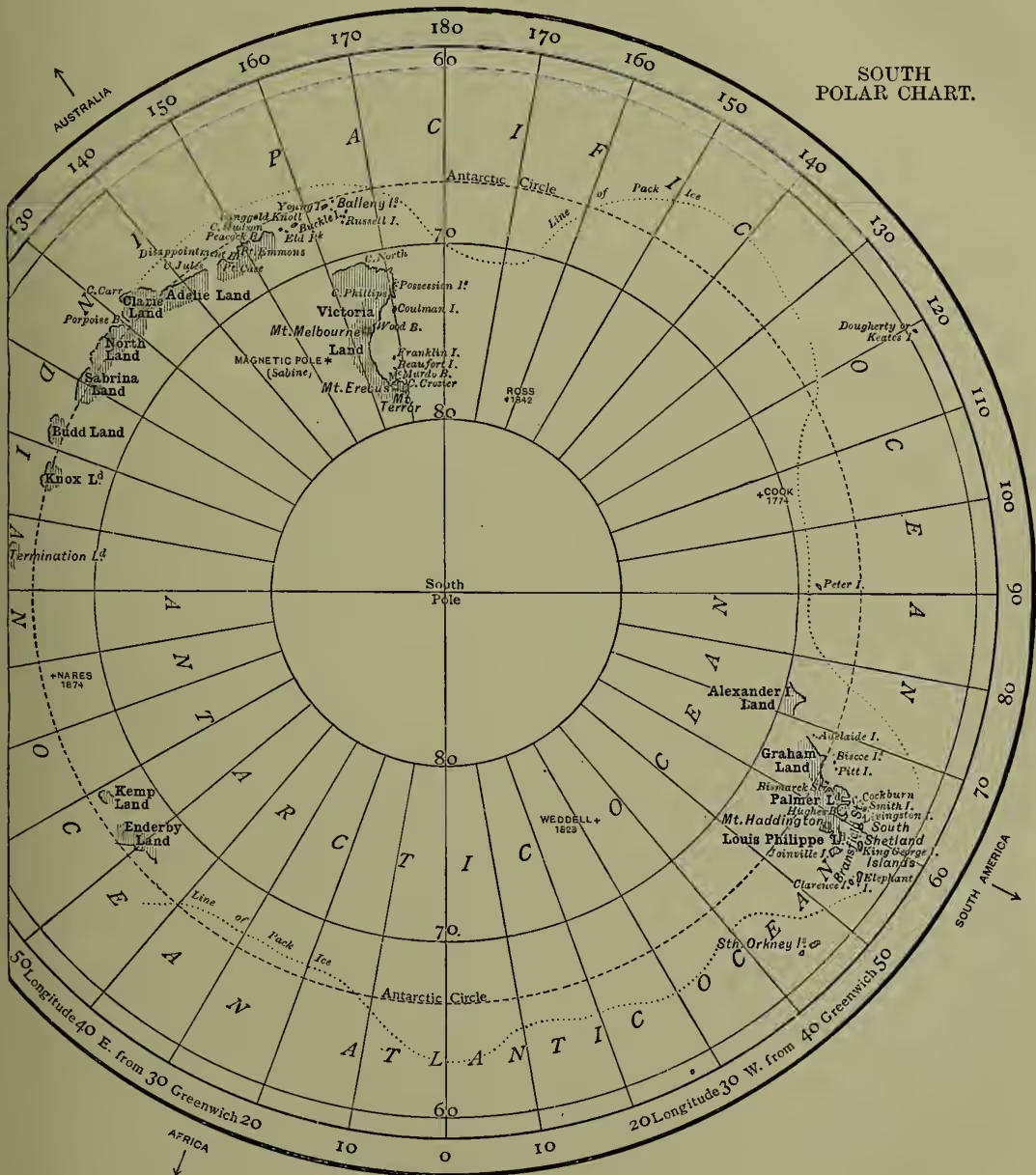
It only now remains to survey shortly the polar explorations of the mighty Southern or Antarctic Ocean. Some of the earlier navigators of the 16th and 17th century were drifted south as far as South Georgia and South Shetland. Cook was the first to undertake a systematic exploration of the region, sailing all round at a high latitude, and so disproving the existence of the 'Great Southern Continent' to be found on old maps. Cook reached , in In 1821 the Russian Bellinghausen discovered the islands named Alexander Land and Peter Land. Weddell afterwards sailed south to , and in 1831 Biscoe discovered Enderby Land, , and Graham Land, The French expedition, 1838, under D'Urville, found its advance to the pole blocked by a bank extending east and west for 300 miles; La Terre Adèle, in , was first named in this voyage. In 1840 the United States expedition under Captain Wilkes discovered a long coast-line, apparently extending from Enderby Land eastwards to Ringold's Knoll, but the only part of this which has since been found was discovered by Balleny in 1839. The most important results obtained in the Antarctic region are due to Sir James Clarke Ross, who made three voyages in 1839-43, discovering Victoria Land, with a lofty range containing the volcanoes Erebus and Terror. He traced the coast from to , the highest latitude yet reached in the Antarctic, after passing some ice-floes which were 1000 miles broad. These southern expeditions of Ross, like those of all the chief polar explorers, have supplied valuable information for students of magnetism, meteorology, geology, and natural history, besides extending the bounds of geographical science. The Challenger expedition only just crossed the Antarctic circle.
The general result of all the exploring work is that in the north polar regions the unknown has been pushed back to within lat.; while in the Greenland and the Nova Zembla regions exploration has been carried to within about 400 miles from the North Pole. On the other side, with the exception of patches here and there, the south polar region is a great blank within the Antarctic Circle. The German government subsidised a scientific expedition to the Antarctic to start in 1901; a national British expedition, organised by the Royal Geographical Society, with funds provided partly by subscription and partly from government, co-operates with it, each exploring a separate part of the ocean.
The physical geography of the north and south polar regions is largely treated at ARCTIC OCEAN, ANTARCTIC OCEAN. See also GEOGRAPHY, GEOGRAPHICAL DISTRIBUTION, GREENLAND, SPITZBERGEN, NOVA ZEMBLA, FRANZ-JOSEF LAND, SIBERIA, NEW SIBERIAN ISLANDS, OB, GLACIER, ICE, and the articles on Hudson, Cook,
Franklin, Ross, Parry, M'Clure, McClintock, Hall, Nordenskiöld, Greely, and other Arctic and Antarctic explorers; Barrow's History of Voyages to the Arctic Regions (2 vols. 1818 and 1846); C. R. Markham's Threshold of the Unknown Region; A. R. Markham's Life of Franklin; Edinburgh Review, April 1891; Journal and Proceedings, Roy. Geo. Soc.; and the published narratives of the various Arctic and Antarctic explorations.