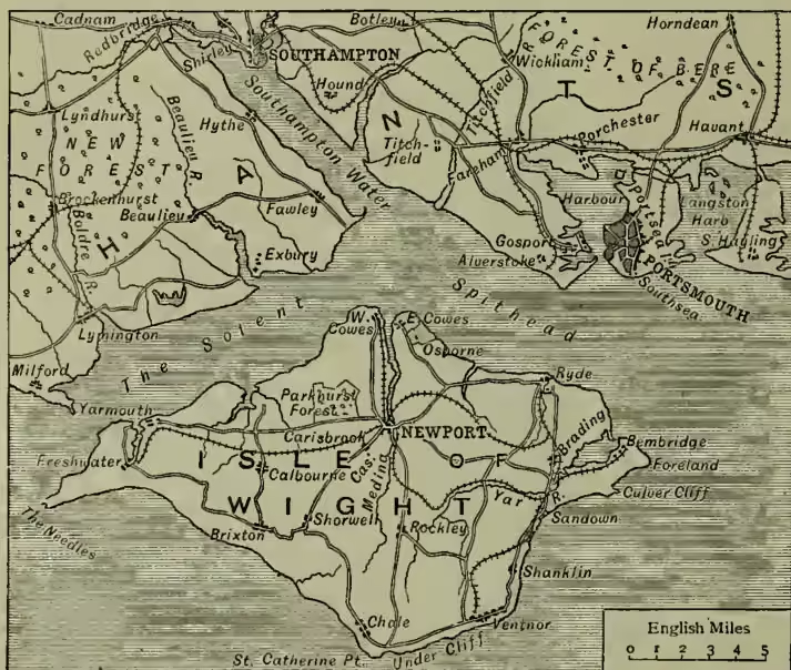
Portsmouth, the chief naval arsenal of Great Britain, and an important seaport, market-town, and municipal, parliamentary, and county borough, in the south of Hampshire, stands on the southwest shore of Portsea Island (q.v.), at the entrance to Portsmouth Harbour, and opposite the town of Gosport (q.v.), with which it communicates by means of a steam-bridge. It is 74 miles SW. of London, 44 W. of Brighton, and 23 SE. of Southampton. Besides the parish of Portsmouth, the limits of the municipal and parliamentary borough, which are co-extensive, include also the parish and town of Portsea, and the out-wards Landport and Southsea, and comprise the whole of Portsea Island, with the exception of a small portion in the northeast corner. Pop. of the borough (1821) 69,479; (1851) 72,096; (1871) 113,569; (1881) 127,989; (1891) 159,255. Portsmouth is for the most part a mean-looking, dirty town, but has the most complete fortifications in Britain. These comprise, on the landward side, the outer line of the Portsdon forts and the Hilsea lines; to seaward, the Spithead (q.v.) forts. A portion of the bastioned ramparts, which formerly encircled both Portsmouth and Gosport, and were so imposing in appearance, have since 1872 been removed as useless. Southsea, which is situated outside the walls skirting Southsea Common, is rapidly increasing, and is now a fashionable watering-place. In the town proper there are few objects of note. Pleasing views may be had from the ramparts and batteries, of the harbour, the roadstead of Spithead, and the Isle of Wight. Many improvements have been carried out in Portsmouth, including improved drainage, and the opening of the Victoria Park in 1878; also a new town-hall has been built at a cost of £140,000, which was opened by the Prince of Wales in 1890. Among the few notable buildings may be mentioned the church of St Thomas, whose chancel and transept date from the close of the 12th century, the nave and tower from 1698, and which contains a ghastly cenotaph in memory of the murdered Duke of Buckingham. The Garrison Chapel, Early English in style, and finely restored by Street in 1867, is a fragment of the hospital of St Nicholas, founded in 1212 by Bishop Peter de Repibus. In it Charles II. married Catharine of Braganza; and in front of it is buried the brave Sir Charles James Napier (q.v.), who died in this neighbourhood in 1853. The dockyard of Portsmouth, in the district of Portsea, was till 1872 only 116 acres in extent; but vast works have since then been carried out at a cost of £2,500,000, which have increased the area to a total of 293 acres. Of this immense naval establishment the most noteworthy, if not the most recent, features are the mast and rope houses, hemp-stores, rigging-stores, sail-loft, and the dry-docks, spacious enough to admit the largest vessels, and offering every facility for their speedy repair. The twelve docks, 22 to 36 feet deep, are lined with solid masonry, roofed over, and closed by lock-gates. Of the various building-slips, one of them, roofed and covered in, is so large that three or four vessels can be in process of construction under it at the same time. The Wood Mills contain a number of most ingenious block-making machines, the invention of Sir Isambard Brunel (q.v.), in which rough timber, introduced at one end, is cut, squared, drilled, bored, and turned into the required shape. About 150,000 blocks are made here annually, and the machines require the attendance of no more than four men. In the smithy anchors are forged by aid of a Nasmyth's hammer.
The dockyard also contains the residences of the superintending officers, and a school of naval architecture.
Portsmouth Harbour, about 400 yards wide at its entrance, expands into a spacious basin, extending inland for about 4 miles, and having a breadth of 3 miles along its northern shore. Large war-vessels can enter and lie at anchor at all times of the tide, there being 4 fathoms of water in the channel at low water. The outward entrance is defended by Forts Monckton and Gilkicker, and Southsea Castle. The position of this harbour is highly favourable. It is situated in the middle of the channel, close to the magnificent anchorage of Spithead, where 1000 ships of the line may ride without inconvenience, and is under shelter of the Isle of Wight, and opposite the French arsenal of Cherbourg.
The local trade of Portsmouth is chiefly supported by the dockyard and other public establishments. Brewing is largely carried on. Coals, potatoes, corn, and timber are imported from British coasts, and potatoes, granite, corn, timber, cattle, and wine from abroad. The only exports are pottery (shipped at Fareham) and coal-tar pitch.
The importance of this port dates only from the reign of Henry VIII. Its defences were commenced by Edward IV. and strengthened by Elizabeth, and afterwards in a more thorough manner by William III. Here, in a house that still remains in the High Street, and which was then an inn called the 'Spotted Dog,' the Duke of Buckingham (the 'Steenie' of King James) was assassinated by John Felton. On the 29th of August 1782, when its commander, Admiral Kempenfeldt, was writing in his cabin, the Royal George went down at Spithead, and nearly 1000 lives were lost. Charles Dickens was born at 387 Mile End Terrace, Commercial Road, Landport, Portsea; and other worthies of Portsmouth have been Walter Besant, the younger Brunel, Jonas Hanway, Sir Frederick Madden, George Meredith, and John Pounds.
See L. Allen's History of Portsmouth (1817), H. Slight's Chronicles of Portsmouth (1828), H. P. Wright's Story of the 'Domus Dei' or Garrison Church (1873), W. H. Saunders' Annals of Portsmouth (1880), and Murrell and East's Extracts from Portsmouth Records (1884).