Storms are violent commotions of the atmosphere occurring in all climates, particularly in the tropics, and differing from other atmospheric disturbances in the extent over which they spread and the sudden changes which take place in the direction of the wind over wide areas. There is, perhaps, no question in science in which there was long so large an admixture of speculation with fact as in the attempts made to reduce the phenomena of storms under general laws; the reason being that meteorological observatories were too few in number and too wide apart to represent the barometer pressure, the general course of the winds, and the rainfall, without drawing largely on conjecture. Since about 1860, however, sufficient data have been available for a fuller and more satisfactory statement of the facts.
Form and Extent of Storm Areas.—The circular isobaric lines on the charts represent very fairly the form storms usually assume in Europe, where the area of almost every storm is either circular or elliptical, the major axis of the ellipse being generally less than twice the minor axis. Rarely in Europe, but in America less rarely, is the form of storms much more elongated. The outline is occasionally very irregular, but in such cases the storm will be found to have parted into two or more distinct storms, or it comprises within the low-pressure area several satellite storms. The approximate circular form of storms is their general characteristic. This is a most important feature, whether as determining the practical rules for the guidance of sailors in storms, or for the forecasting of storms at particular seaports, in respect of the direction from which they may be expected to come, and the veerings of the winds during their continuance. The extent over which storms spread is very variable, being seldom less than 600 miles in diameter, but often two or three times greater, and more rarely even five times that amount. More than the whole of Europe is sometimes overspread by a single storm at one time. The prime difference between storms or cyclones and tornadoes is that the breadth of the space traversed by the latter is, as compared with that of storms, always quite insignificant. The area of storms is not constant from day to day, but varies in size, sometimes expanding and sometimes contracting; and it is worthy of remark that when a storm contracts in area the central depression gives signs of filling up, and the storm of dying out. On the other hand, when it increases in extent the central depression becomes deeper, the storm increases in violence, and occasionally is broken up into two or even more depressions, which become separate storms, with the wind circling round each. This occurs frequently with summer thunderstorms.
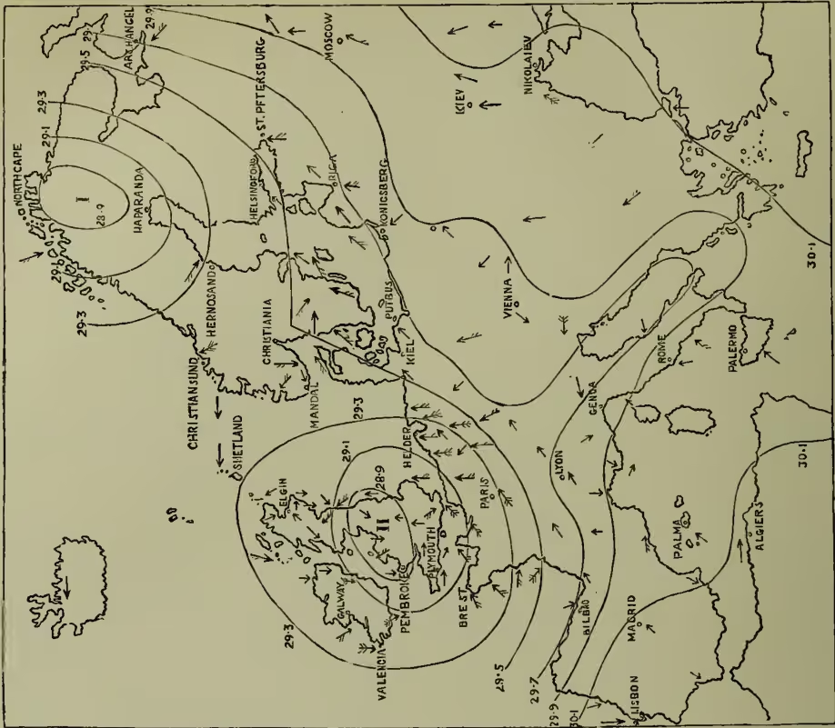
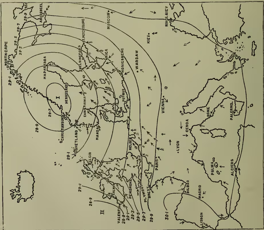
We subjoin two charts of Europe showing from observations made at upwards of 100 stations scattered over the continent the barometric pressure, and direction and force of the wind, at 8 A.M. of the 1st (A) and 2d (B) of November 1863, during part of the course of two storms which passed over Europe. The isobaric lines, or lines showing where, at the above hour, the barometer was the same, are given for every two-tenths of an inch in the difference of the pressure. Hence, where these lines crowd together, the difference of pressure, or the atmospheric disturbance, was the greatest, and the least where they are most apart—a distinction of the utmost importance in determining where the wind raged in greatest fury. The arrows show the direction of the wind, being represented flying with it. The force of the wind is shown (1) by plain arrows, —→, which represent light and moderate winds; (2) by arrows feathered on one side only, >>>→, which represent high winds; (3) by arrows feathered on both sides, >>>>→, which represent strong gales, storms, or hurricanes.
Direction in which Storms advance.—The direction in which their progressive motion takes place differs in different parts of the world—being perhaps determined by the prevailing winds (see WINDS). Thus, about half the storms of middle and northern Europe travel from the south-west toward the north-east, and about nineteen out of every twenty travel toward some point in the quadrant lying between the north-east and the south-east. Storms rarely travel towards a westerly point; in some of the instances which have been noted the western course has been arrested at Norway, Denmark, the North Sea, or the British Islands, but such westerly course is temporary, the easterly course being afterwards resumed. Some of the most violent easterly storms fall under this head. Storms do not always proceed in the same uniform direction from day to day, and, though the change which occurs in the direction of their progressive motion is generally small, yet occasionally it is very great. Thus, of the many interesting features peculiar to the storm which passed over Europe in the beginning of December 1863 none were more remarkable than the sudden changes of its progressive motion. It was first observed on the west of Ireland, from which it advanced east to Liverpool, then turned south through Worcester and Oxford to Cherbourg in France; it thence retreated north through Oxford to Shields, from which it
proceeded east to Copenhagen. By the time it arrived at Copenhagen its extent was only a fourth of what it had been the previous day, and the central depression half an inch less. Twelve hours later the atmospheric equilibrium was restored, the storm having died out on reaching the Baltic Sea. The storms of the Mediterranean follow a different course. While a number take the general easterly course of European storms, a larger number originate in the gulfs of Lyons and Genoa, and pursue devious courses over this northern extension of the Mediterranean, till they die out; several advance from Turkey and Greece towards the Alps; and others, comparatively few, advance in an easterly course towards the Levant. A marked feature of these Mediterranean storms, including those of the Adriatic, is their slow, frequently retrograde, and erratic courses, and the small space traversed by them; and while they last the mistral, with dry cutting wind, sweeps down from the Alps on the health-resorts of southern France. By far the greater number of the storms of North America take their rise in the vast plain which lies to the east of the Rocky Mountains, and thence advance in an eastern direction over the United States, their course being largely determined by the great lakes; some of them cross the Atlantic, and burst on the western shores of Europe. But the connection of the American with the European storms is not even yet well established. The storms of the West Indies generally take their rise somewhere north of the region of calms, and, tracing out a parabolic course, proceed first towards the west-north-west, and then turn to the north-east about N. lat., not a few traversing the east coasts of North America as far as Nova Scotia. South of the equator they follow an opposite course. Thus, in the Indian Ocean they first proceed toward the south-west, and then gradually curve round to the south-east. The hurricanes of India usually pursue a parabolic path, first traversing the eastern coast towards Calcutta, and then turning to the north-west up the valley of the Ganges. The typhoons of the Chinese Seas resemble, in the course they take, the hurricanes of the West Indies.
Probably the course tracked out by storms is determined by the general system of winds which prevail, modified by the unequal distribution of land and water on the surface of the globe, the diffusion of the aqueous vapour, and its concentration over the regions traversed by the storms. Facts seem at present to point to the general conclusion that storms follow the course of the atmospheric current in which the condensation of the vapour into the rain which accompanies them takes place.
Rate at which Storms travel.—If the position of the centre of storm I. in chart B be compared with its position on the 1st on the charts, it will be found to have travelled 420 miles in 24 hours, or at the rate of miles an hour. Similarly storm II. will be found to have travelled in the same time 400 miles, or at the rate of miles an hour. This is not far from the average rate of the progressive movement of European storms. From an examination of extensive series of storms Professor Loomis has shown that the average rates of progress of storm centres are in miles per hour 28 for the United States, 18 for the middle latitudes of the Atlantic Ocean, 17 for Europe, 15 for the West Indies, and 9 for the Bay of Bengal and China Sea. On January 7–8th 1877 a storm travelled in 24 hours from Indianola (Texas) to Eastport (Maine)—1872 miles, or 78 miles an hour. On the other hand, the rate of progress is, particularly in the tropics, sometimes so slow as to be virtually stationary; and, as already stated, they occasionally recurve on their paths.
Relations of Temperature, Rain, and Cloud to Storms.—Temperature increases at places toward which and over which the front part of the storm is advancing, and falls at those places over which the front part of the storm has already passed. In other words, the temperature rises as the barometer falls, and falls as the barometer rises. When the barometer has been falling for some time clouds begin to overspread the sky, and rain to fall at intervals; as the central depression approaches the rain becomes more general, heavy, and continuous. After the centre of the storm approaches, or shortly before the barometer begins to rise, the rain becomes less heavy, falling more in showers than continuously; the clouds break up when the centre has passed, and fine weather, ushered in with cold breezes, ultimately prevails. If the temperature begins to rise soon and markedly after the storm has passed, a second storm may be shortly expected.
Direction of the Wind.—If the winds in storm II. in chart B be examined, they will be observed whirling round the area of low barometer in a circular manner, and in a direction contrary to the motion of the hands of a watch, with a constant tendency to turn inwards towards the centre of lowest pressure (i.e. in the manner formulated in Buys-Ballot's law). The wind in storms neither blows round the centre of lowest pressure in circles, nor does it blow directly towards that centre, but takes a direction nearly intermediate, approaching, however, nearer to the direction and course of the circular curves than of the radii to the centre. In the front of the storm the winds blow more towards the centre, but in the rear they blow more closely approximate to the circular isobaric lines. Where the direction of the wind differs to any material degree from the above it is light, and consequently more under local influences, which turn it from its true course. Thus, the centre of the storm being near Liverpool, the direction of the wind is south-west at Paris, south at Yarmouth, north-east at Sillott, north at Dublin, and north-west at Cork—instead of south at Paris, south-east at Yarmouth, north at Sillott, north-west at Dublin, and west at Cork, if it had blown directly to the area of lowest pressure, and west at Paris, south-west at Yarmouth, east at Sillott, north-east at Dublin, and north at Cork, if it had circulated in the direction of the isobaric curves. Hence in this storm the winds circulate round the centre of least pressure, or, to speak more accurately, the whole atmospheric system flows in upon the centre in a vortex-like manner. This peculiarity is common to all storms in the northern hemisphere that have yet been examined. In the southern hemisphere a rotatory motion is also observed round the centre of storms, but it takes place in a contrary direction, or in the direction of the motion of the hands of a watch, instead of contrary to that direction, as obtains north of the equator.
Professor Taylor first applied Dove's law of rotation to explain the direction of the rotation of storms round their centre. This may be explained by referring to storm II. in chart B. On that morning the pressure over England being much less than in surrounding countries, if the earth had been at rest air-currents would have flowed from all directions to England, to fill up the deficiency, in straight lines. The earth, however, is not at rest, but revolves from west to east; and, as the velocity of rotation diminishes as the latitude increases, it is evident that the current, which set out say from Lyons to the north, would, on account of its greater initial velocity when it arrived at Paris, blow no longer directly to the north, but to a point a little to the east of north; in other words it would no longer be a south, but a south-west wind. Again, since the current from the north of Scotland had a less velocity than those parts of the earth's surface on which it advanced, it lagged behind, and consequently by the time it arrived at Silloth in the north of England had changed from a north to a north-east wind. Similarly the north-west current changed to a north, the south-west to a west, &c. The west and east currents, since they continued in the same latitude, would have blown in the same direction, if they had not been disturbed by contiguous currents. Hence in a storm the whole system of winds appears to rotate round the centre. As a further confirmation of this theory, it is observed that when a high pressure covers a limited space the wind is always observed gently whirling out of this area of high barometer, but in exactly opposite directions in both hemispheres from those assumed when it blows round and in upon an area of low pressure. It follows in the northern hemisphere that as storms advance the general veering of the wind at places lying north of the path of their centre is from north-east by north to west, and at places south of their centre from north-east by east and south to north-west, and conversely in the southern hemisphere.
Force of the Wind.—The rule is simple, and without exception—viz. the wind blows from a high to a low barometer with a force proportioned to the barometric gradient or to the difference of the barometric pressures reduced to sea-level. Hence where the isobaric lines crowd together the violence of the storm is most felt, and where they are far asunder the winds are moderate, light, or nil. We thus see the importance of observations from a distance in forecasting the weather. To take an illustration: the importance of observations from Norway and Sweden to all seaports on the east coast of Britain cannot be overestimated, for if the pressure be high in Norway and low in the North Sea or in the south of Great Britain violent easterly gales will sweep down on Scotland, and, unless foreseen and provided against, strew the coast with wrecks; whereas if the pressures be nearly equal little danger need be apprehended, even though the barometer be low in Britain. As the wind nears the centre of the storm it gradually abates, till on reaching the centre a lull or calm takes place—a peculiarity more uniformly noted as regards tropical storms. Calms and light winds also prevail along the ridge of highest barometer, or the region where the pressure is greatest, and on receding from which the pressure diminishes on each side. This arrangement of the pressure is accompanied with fine weather and the 'pet' days of winter. It may not inaptly be compared to the watershed in physical geography, since from it the wind flows away on either hand towards the places where pressure is less.
The progressive motion of storms, which may vary from zero to 78 miles an hour, measures the time taken in passing from one place to another, but it gives no indication of the violence of the storm. This is determined by the velocity of the wind round and inwards upon the centre of the storm, which in Europe and America frequently amounts to 60 or 80 miles an hour continuously for some time. In intermittent gusts a speed of 120 miles an hour has been several times observed in Britain—a velocity which is perhaps sometimes surpassed by storms within the tropics. On the top of Ben Nevis higher velocities, rising to upwards of 150 miles, are of not infrequent occurrence.
Cause of Cyclones.—Dove, who did so much in this department of meteorology, held the view that cyclones are formed when two great atmospheric currents, called polar and equatorial, flow side by side, storms being the eddies, as it were, formed along the line of junction. It is to be kept in mind that the qualities of the atmosphere in the front portion of a cyclone are quite different from those in the rear—the former being warm and moist, while the latter are cold and dry. The conclusion is inevitable that the apparent rotation of winds in storms is simply a circulatory movement maintained between two currents, and that no mass of the same air makes the complete circuit of the cyclone. This feature of storms will, if rightly apprehended, play an important rôle in the development of the theory of the law of storms which lies yet in the future. The height to which storms extend in the atmosphere, as has been shown from the Ben Nevis observations, is greatly less than had been supposed.
Forecasting.—Valuable aid in forecasting storms and weather is derived from two important deductions from past observations: I. A cyclone tends towards a path near to the anticyclone which lies immediately to the right of the progressive motion of the storm at the time. II. When the rates of fall of the barometer at stations in the west of Europe are noted, it is found that the path taken by the coming storm is indicated by those stations at which the rates of fall of the barometer are greatest.
Relation of Storms to the Character of the Season.—This is vital and all-important. Thus, as regards the British Islands, when the general path pursued by storms in their easterly course over Europe lies to the southward the winter is severe, inasmuch as the British Islands are then on the north side of the centre of low pressure, and consequently in the stream of the northerly and easterly winds which there prevail. On the other hand, when the paths of storms lie to the northward the British Islands are on the south side of the low pressure, and therefore in the stream of the warm, moist, southerly and south-westerly winds which there prevail. The weather of December 1890 and that of February 1891 illustrate these two distinct types of weather. In December 1890 the weather was colder in the southern counties of England than it had been during the present century. At Oxford the temperature was 10°0' under the average, and in the south-western provinces of Russia the mean temperature was fully 14°0' below the average. On the other hand, to the north of a line drawn from Wilna to Bergen temperature was above the average, the excess above the mean increasing on advancing northward till in the north of Norway it was 10°0', and at the entrance of the White Sea 13°0'. In the same month in the Eastern States and Canada temperature was under the average, the deficiency being 11°5' at Montreal; whereas over the rest of the United States temperature was high, the excess increasing on proceeding northward till, in Assiniboia, it was from 14°0' to 17°0' above the average. The explanation is at once afforded by the distribution of atmospheric pressure at the time. In Europe pressure was unusually high from the north of Scotland to St Petersburg. But, what is of more importance, it diminished steadily southward over the continent and into the north of Africa, and, on the other hand, also diminished steadily over the north of Europe, being 0.350 inch lower at the North Cape than at Bergen. Consequently the whole of the southern half of Europe was swept by northerly and easterly winds, bitterly cold and dry, and temperature fell unprecedentedly low; but in the north southerly and south-westerly winds inevitably prevailed, bearing to the northern climes the warmth of lower latitudes. In America atmospheric pressure was above the average over a broad area extending from New Orleans to Lake
Huron, while on the one hand over the Eastern States and Canada it fell below the average, and on the other also below the average over Assiniboia. From this distribution of pressure it inevitably resulted that Canada and the Eastern States were swept by cold, dry, north-westerly winds of unusual strength and prevalence, while Assiniboia enjoyed southerly breezes from, as the isobaries and winds show, the low latitudes of the Gulf of Mexico.
It is plain that the character of the weather of any particular day or season is wholly determined by the way in which areas of high and of low atmospheric pressure are distributed over the region during that day or season. Further, the weather of the coming season could certainly be predicted for say the British Islands, if only the general path was known which the centres of the Atlantic cyclones will take in their easterly course over Europe; for if the paths of the winter storms be to the north of Great Britain the winter will be an open one, but if to the south a severe winter is the certain result. Towards the solution of this highly practical problem we look to seamen to put us in possession of a fuller and, above all, an earlier knowledge of the fluctuations of the surface temperature of the Atlantic, and to high-level observatories for the data required in obtaining a clearer insight into the history and theory of storms.
See METEOROLOGY, SIGNALLING, HAILSTORM, ANEMOMETER, WIND, &c.; Redfield, On the Law of Storms (1840); Espy, The Philosophy of Storms (1841); Peddington, Application of the Law of Storms to Navigation (1844); Sir W. Reid, Progress of the Development of the Law of Storms (1849); Dove, On the Law of Storms (Eng. trans. 1862); Meldrum, Law of Storms and Navigation (1873); Ferrel, Storms, Tornadoes, and Waterspouts (1878); Loomis, Contributions to Meteorology (3 parts, 1885-89); H. G. Hazen, The Tornado (New York, 1890); and the daily weather charts and relative memoirs published in Great Britain, United States, Canada, Australia, France, Holland, Germany, Austria, Denmark, Sweden, Russia, India, China, Japan, &c.