
from the Baths at Pompeii.
Atlantic Ocean. The Atlantic Ocean, so called either from Mount Atlas or from the fabulous island of Atlantis, separates the Old from the New World, Europe and Africa being on the E., and North and South America on the W. Its greatest width is about 5000 miles, but between Brazil and the African coast the distance is only about 1600 miles. It is in open communication with both the Arctic Ocean and Antarctic or Southern Ocean. The North Atlantic, stretching from 70° N. to the equator, has an area of 14,000,000 sq. m. It communicates with many inclosed or partially inclosed seas, such as the Caribbean Sea, Gulf of Mexico,
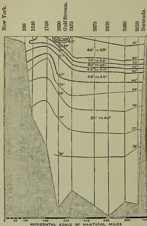
Showing the Soundings (in fathoms) and Isothermal Lines obtained in H.M.S. Challenger. The vertical scale, as compared with the horizontal, is as 400 to 1; so that the inclines are 400 times less steep than represented. It was necessary to adopt this exaggerated scale in order to show the relative position of the Isothermal Lines. and Hudson Bay on the west, the Baltic, North Sea, Mediterranean, and Black Sea on the east, whose combined areas are about 3,400,000 sq. m. The South Atlantic from the equator to 40° S. has an area of 10,100,000 sq. m.; if it be supposed to extend through the great Southern Ocean as far as the Antarctic circle, its area is 16,700,000 sq. m. Including the Arctic Ocean and the other seas with which it is in open communication, the Atlantic has a drainage area of 26,400,000 sq. m. On this land, draining directly or indirectly into the Atlantic, Mr Murray estimates there is a rainfall of 15,800 cubic miles annually, and that the annual discharge of rivers into the Atlantic is 3400 cubic miles of water, equal to about one-half the rainfall and river discharge of the world.
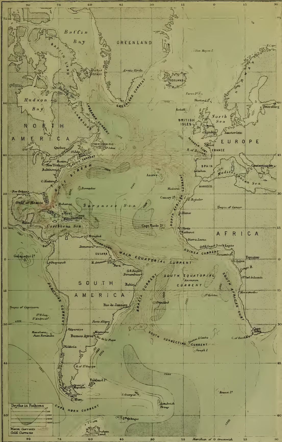
Towards the centre of the North Atlantic, between Africa and North America, and in the centre of the South Atlantic, between Africa and South America, there are anticyclonic areas of high atmospheric pressure (over 30 inches), out of which winds blow in all directions to surrounding regions where the pressure is less. For instance, to the westward of North Africa, the prevailing winds are northerly and north-westerly; on the south side of the anticyclonic region they are easterly; and on the west, off the North American coast, they are southerly. A similar system of winds prevails in the South Atlantic. The positions of these high-pressure areas and the winds that blow out from them, determine the great oceanic currents and the positions of the Sargasso seas, for the winds everywhere determine and control the movements of the surface waters. The SE. and NE. trades drive the heated surface waters of the tropics before them, and eventually produce the Equatorial current, which on reaching Cape St Roque bifurcates, one branch becoming the Brazil current of the South Atlantic, the other and larger branch passing on to the Caribbean Sea and Gulf of Mexico, finally issuing from the latter by the Strait of Florida, forming the Gulf Stream, the greatest and most important of all oceanic currents. The Gulf Stream spreads out over the Atlantic to the south of Newfoundland; one prolongation of it returns to the tropics off the coasts of Spain and Africa, the other passes north between the British Isles and Iceland, and on to the coasts of Norway, which are thus rendered habitable, while the opposite coasts of Greenland are ice-bound. A cold Arctic current passes southward along the shores of Greenland, and unites off Cape Farewell with the Davis Strait current, forming the Labrador current, which passes along the west coast of America, and passes beneath the Gulf Stream to the south of the banks of Newfoundland. Icebergs are carried as far south as 40° N. in the northern and as far north as 38° S. in the southern hemisphere. In the equatorial regions, the surface water has generally a temperature ranging from 70° to 84° F.; the temperature decreases as the depth increases, the coldest water being found at the bottom. The warm water is a relatively thin stratum, the greater part of ocean water having a temperature below 40° F. It is ice-cold in the Atlantic at the bottom even beneath the equator; the ooze dredged from the bottom beneath a tropical sun is so cold that the hand cannot be placed in it without great discomfort. The low temperature of deep ocean water is acquired in the polar regions chiefly in the high latitudes of the southern hemisphere.
The warm salt water carried into the North Atlantic by the Gulf Stream slowly sinks on account of the reduction of temperature on reaching higher latitudes, and carries heat down with it, consequently relatively warm water is found at a greater depth in the North Atlantic than in any other ocean. A temperature of 45° is found off the north of Scotland at a depth of 600 fathoms (three-fourths of a mile), while off the west coast of Africa a similar temperature is met with at only 200 fathoms beneath the surface. The temperature of the ocean is colder off the leeward shores of continents than on the weather shores, as the cold deep water is drawn up to the surface to supply the place of that driven before the winds: this is probably the reason why coral reefs are absent in the eastern parts of the ocean in the tropics, while they flourish in the western. The water of the Atlantic is freshest—that is, contains the least salt—towards the poles and in the equatorial belt of calms. The saltiest water (density over 1.0275) is found in the centre of the trade-wind regions. This is not, however, so salt as the Mediterranean and Red Sea (over 1.0280). The salinity of the deeper waters is considerably below the average of the surface. The average depth of the Atlantic is between 2 and 3 miles (2200 fathoms). A low submarine ridge runs down the centre, from north to south, with an average depth of about 1700 fathoms over it. On either side of this ridge there are, both in the North and South Atlantic, depths of between 3000 and 4000 fathoms. The greatest depth yet met with is just north of the Virgin Islands, where a sounding of 4561 fathoms has been obtained. The deposits towards the central portions of the Atlantic are chiefly made up of the dead calcareous shells of
ATLANTIC OCEAN

organisms which have fallen from the surface. On the central elevation, where the depths are less than 1500 fathoms, the deposits are largely made up of the shells of pelagic Molluscs, and the deposits are called Pteropod ooze; from 1500 to 3000 fathoms, the shells of pelagic Foraminifera prevail, and the deposits are named Globigerina ooze. In depths greater than 3000 fathoms there is a reddish clay, chiefly made up of disintegrated pumice and other volcanic material. Near the shores there is a mixture of land débris and surface organisms, and the deposits are red and blue muds, green glauconitic muds and sands, coral and volcanic muds and sands. The surface waters from equator to poles swarm with all kinds of pelagic plants and animals, many of which emit phosphorescent light, producing what is known as luminosity of the sea. In the centre of the North Atlantic, in the so-called Sargasso Sea, there are enormous floating banks of gulf weed (Sargassum bucciferum), on which a large number of peculiar animals live. Life has been found to exist at all depths in the Atlantic, but it becomes less abundant as greater depths and a greater distance from continental shores are reached. There are relatively few oceanic islands. Iceland, the Azores, St Paul's Rocks, Ascension, and the Tristan da Cunha group all rise from the central elevation, and are all of volcanic origin. Jan Mayen rises from the deep water of the Norwegian Sea. The coral group of Bernudas rises from the deep water of the Western North Atlantic. Off the west coast of Africa are the Canaries, Cape Verdes, and Madeira. In the South Atlantic, to the west of the central ridge, are Fernando Noronha and Trinidad, and to the east of the central ridge, St Helena. There are numerous continental islands, such as the British Isles, Newfoundland, the West Indies, the Falklands, and others. The most civilised nations of the world inhabit the shores of the Atlantic, and it is the great commercial highway of the world. Its coasts are better surveyed, better provided with lighthouses, and its winds and currents better known than those of any other ocean. It has been sounded in all directions, and the nature of its bed is so well known that telegraph cables can be laid across it with great certainty of success. In the neighbourhood of some continental shores, and around some of the volcanic cones which rise from the floor of the ocean, there are occasionally very steep slopes; but as a rule, the bed of the ocean is a widespread, gently undulating plain. The GULF STREAM has a separate article (q.v.).