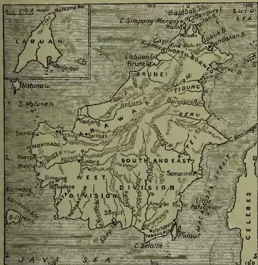
Borneo, next to Australia and Papua the largest island in the world, is situated in the Indian Archipelago, in 7° 3' N.—4° 10' S. lat., and 108° 53'—119° 22' E. long. It is bounded on the E. by the Sea of Celebes and the Macassar Strait, S. by the Sea of Java, W. and N. by the Gulf of Siam and the China Sea. Its length is about 800 miles, with a breadth of 700, and an area of about 284,000 sq. m. The population is roughly estimated at 1,365,000, but may be more. The coasts, which are often low and marshy, and rendered dangerous to navigation by numerous islets and rocks, present no deep indentations, though they are pierced by numerous small bays and creeks. A great part of the island must be described as mountainous; but the relations of the various ranges and groupings are still very imperfectly known, and in very few cases has the altitude of the leading summits been accurately ascertained. In the far north rises the magnificent structure of Kinabalu (13,698 feet high), built up of porphyritic granite and igneous rocks—the culminating peak probably of the whole Indian Archipelago, and not unworthy in its picturesqueness of such a rank. Throughout the narrow northern portion of the island there runs a kind of central ridge in a general south-west direction, with highest points ranging from 4000 to 8000 feet; and this can be traced, at least as a water-parting, far to the south-west; though broadly speaking, the whole southward country is corrugated and crinkled, as it were, in a most irregular manner. This is the result of the great process of denudation carried on by the tropical rains, which, scooping out the interior valleys and plains, have laid down the vast alluvial tracts that extend seawards into deltaic morasses. As far as is yet known, the mountain framework of the whole island consists, like Kinabalu, of eruptive and crystalline rocks of high antiquity. Of modern volcanic activity, so prevalent elsewhere in the Indian Archipelago, there is in Borneo no trace either in tradition or in the record of the rocks. A large proportion of the surface, not covered by alluvium, consists of tertiary deposits, in regard to the age of which, however, geologists are not agreed. Pages might be filled with the mere nomenclature of the rivers of Borneo; the more important may be seen on the accompanying map. Though many are powerful streams, navigable far inland for boats of considerable burden, their value as waterways is lessened by the bars which usually prevent the entrance of sea-going vessels, and in their upper reaches by frequent rapids and occasional waterfalls. In connection with the river-systems there are numerous lakes in Borneo; but of true mountain-lakes on a large scale there are probably few. The great lake of Kinabalu, which figured in older accounts with 100 miles of circumference, is a pure myth, based perhaps on a misunderstood description of the great grass-covered plain of Danao.
The climate in the low grounds is humid, hot, and unhealthy for Europeans; but in the higher parts towards the north the temperature is generally moderate, the thermometer at noon varying from 81° to 91° F. During the rainy season, from November to May, heavy storms of wind with loud thunder are experienced on the west coast. The influence of the land and sea breezes passes inland to quite remarkable distances across the level plains and up the river-valleys. Vegetation is extremely luxuriant. The forests produce iron-wood, bilian, teak, ebony, sandal-wood, gutta-percha, dye-woods, benzoin, wax, dragon's blood, sago, various resins, vegetable oils, and gums. The camphor of Brunei is the best in Asia. The mohor tree, well adapted for making native boats, attains a height of 80, and the kaladang, suited for large masts, of 200 feet. Nutmegs, cloves, cinnamon, pepper, betel, ginger, rice, millet, sweet potatoes, yams, cotton in Amuntai, sugar-cane in Sambas and Monrado, indigo, tobacco, coffee in Sambas, pine-apples, coco-nuts, &c., are cultivated. The mountains and forests contain many monkeys, among which is the orang-outang. Tapirs, a small kind of tiger, small Malay bears, swine, wild oxen or banteng, and various kinds of deer abound. The elephant is only found in the north, and the rhinoceros in the north-west. The few domesticated animals are buffaloes, sheep, goats, dogs, and cats. A few horses are seen in Banjermassin. Among the birds are eagles, vultures, Argus-pheasants, peacocks, flamingos, pigeons, parrots, and the swallows (Collocalia esculenta) which construct the edible nests prized by the Chinese for making soup. The rivers, lakes, and lagoons swarm with crocodiles, and many kinds of snakes, frogs, lizards, and leeches. Fish is plentiful, and the coasts are rich in tortoises, pearl-mussels, oysters, and trepang. Brilliant butterflies and moths are in great variety. Among the mineral products are coal, gold, and copper, especially in Monrado; antimony, iron, tin, platina, nickel, diamonds and other precious stones, rock-crystals, porcelain-clay, petroleum, and sulphur. The diamond mines are chiefly in Landak and Pontianak (q.v.); Sambas produces the greatest quantity of gold; the kingdom of Brunei, Kutei, and Banjermassin, the largest amount of coal. The Pengaron coalfield, worked by the Dutch government, is one of the most important.
The population consists of three classes: the Dayaks or Dyaks (q.v.), who are the aboriginal heathen inhabitants, and constitute the great bulk of the population; the Mohammedans or 'Malays'—for this name is extended so as to include all professors of Islam, whether true Malays, Buginese, Javanese, Dyaks, or Arabs; and the Chinese. The Dyaks live chiefly in the interior, and employ themselves with tillage and the collecting of gutta-percha, resin, gums, ratans, gold-dust, and wax. They are divided into numerous tribes. The Malays (taking the name ethnographically) dwell on the coasts, are traders and bold sailors. They are more civilised than the Dyaks, cultivate the grounds around their houses, lay out gardens, keep cattle, and live partly by fishing. The Chinese, chiefly from Canton, have penetrated far into the interior. They engage in trade and mining, are unwearyed in their efforts to make money, and then return to their native country. They have always endeavoured to live as independent republics (kong-si) under chiefs chosen by themselves, and according to Chinese laws. In 1857 the Chinese living in Sarawak rebelled, and were nearly exterminated. The Dutch were also compelled to put them down by force of arms, and have imposed a poll-tax.
The women of Borneo, except the Dyak, weave cotton fabrics, make earthenware, baskets, and mats of beautiful designs and colours. In the district of Banjermassin are factories of weapons. The principal exports are gold, gold-dust, diamonds, coal, ratans, gutta-percha, edible nests, cotton, wax, timber, dye-woods, mats, resins, sandal-wood, camphor, &c.; the imports, earthenware, iron, steel, and copper work, piece-goods, yarns, woollen and silk fabrics, medicines, provisions, wines, spirits, rice, sugar, tea, tobacco, opium, trepang, gambir, gunpowder, &c.
Borneo has never formed a political unity, and there is no native designation for the island as a whole. The name Borneo (Burnei or Brunei) in fact properly applies only to the Malay kingdom on the north-west coast; and Kalamantan or Kalamantin, sometimes quoted as a general appellation, is also of limited purport. The following are the present political divisions:
(1) Borneo Proper.—This originally included nearly the whole of the north-west of the island. The sultan has absolute authority. In 1847 he undertook not to surrender any of his territory to any other power without the sanction of the British government. The capital, Brunei, 20 miles from the coast, on the river of the same name, has at the most 20,000 inhabitants. The population of the country within its present limits may be stated at 125,000. Its area was reduced by the erection of
(2) Sarawak (q.v.) into a practically independent principality by Sir James Brooke (1841–68), though, like Brunei itself, the much larger state of Sarawak has since 1888 been under British protection; as also by the establishment of
(3) The British North Borneo Company as a recognised governing body. The company's charter, granted in 1881, transferred to them rights originally obtained by an American adventurer in 1865. This territory consists partly of a portion of the old kingdom of Brunei, partly also of districts on the east coast, claimed by the sultan of the Sulu Islands. Against the British occupation of the Sulu territory, a protest was made by Spain, which had for some time been gradually incorporating the sultan's possessions. As a matter of fact, the British North Borneo Company has been successful in appropriating and developing its territory, which, with an area of 30,709 sq. m., and a coast-line of 900 miles, is now divided into the East Coast Residency and the provinces of Dent, Keppel, and Alcock, and has its capital at Elopura or Sandakan, the largest settlement, with 5000 inhabitants. The population of the territory is estimated at 200,000.
(4) Dutch Possessions.—By far the largest part of the island is ruled directly or indirectly by the Dutch, who have divided it into the Residency of the Western Division of Borneo, and that of the Southern and Eastern, the former having Pontianak (q.v.) as the seat of government, the latter Banjermassin (q.v.). Besides a number of smaller dependencies, the Western Division contains the kingdom of Landak, Tayan, Mampawa, Sukadana, Simpang, Matan, Sekadow, Sintang, Sambas. Among the separate states which go to form the Southern and Eastern Division are Kotaringin, Banjermassin, and Martapura. In consequence of a decree of the sultan of Banjermassin, the district watered by the Great Dyak or Kahayan is preserved for the native tribes, who in 1879 were estimated at 18,000 souls; Chinese, Malays, &c. are forbidden to ascend the river higher than the Kanpore Pilany. The same is the case with the basins of the Kapuas Mururg, known as the Little Dyak district. The population of the whole of the Dutch portion of the island in 1894 was set down at 1,288,000, of whom about 1000 were Europeans, 35,000 Chinese, 2500 Arabs, and the rest 'natives' of various kinds. In the number of natives are included from 200,000 to 300,000 Malays settled along the coast, who used formerly to be counted amongst the strangers.
(5) The Island of Labuan (q.v.), off the coast of Brunei, has belonged to the British since 1846. The chief towns in Borneo are Sambas (10,000), Pontianak (9000), Banjermassin (30,000), Brunei (20,000), and Kuching (12,000).
The Chinese had commercial dealings with Borneo as early as the 5th century, but they made no settlement for a long time after. The Malay kingdom of Borneo proper dates back to the 13th century. Another Malay settlement of later origin, Sambas, was at first dependent on Johore (q.v.) in the Malay Peninsula. Sukadana was founded by Hindu Javanese from the kingdom of Majapahit (see JAVA), and spread its influence on the whole south part of the west coast. Mampawa was a Buginese settlement, and Pontianak was founded as late as 1771 by a colony of Arabs, Malays, and Buginese. Islam began to be preached by Arabs from Palembang in the 16th century.
The Portuguese effected a settlement in 1690 at Banjermassin; from whence they were, however, soon expelled. The Dutch succeeded in concluding a treaty of commerce with the princes of Banjermassin. They erected a fort and factory in 1643, and a second in 1778 at Pontianak. The British made unsuccessful attempts in 1702 and 1774 to effect a settlement in Borneo, but have within the present century acquired a preponderating influence on the north-western coast. See Wallace's Malay Archipelago (1869); Burbidge's Garden of the Sun (1880); Bock's Head Hunters of Borneo (1881); Frank Hatton, North Borneo (1885); Handbook of British North Borneo (1886); J. J. de Hollander, Nederlandsch Oost Indië (1884); Posewitz, Borneo (trans. by Hatch, 1892).