Suez, a town of Egypt, is situated at the southern extremity of the Suez Canal and on the Gulf of Suez, a northern arm of the Red Sea. Close beside the town the Peninsular and Oriental Steamship Company have extensive storehouses and magazines, there is a large English hospital, and the sweet-water canal from Ismailia terminates here. The railway from Ismailia runs through the town on to the spacious harbour 2 miles beyond. The streets are generally neglected and uneven, and by night unlighted. Suez has not a very large trade of its own (£800,000 to £900,000 annually); most of the commerce passes through it without making halt. Pop. (1890) 13,000. The town is surrounded by the desert. At more than one period in the past this place was the seat of a flourishing trade, as for instance in the time of the Ptolemies, when it was called Arsinoë; under the first Moslem rulers of Egypt, who called it Kolzum, the Greek name being then Clysmia; and from the 16th to the 18th century, when it formed an important étape in the European trade with India; but by the beginning of the 19th century it was again quite decayed. It began to revive when the overland mail route between England and India was opened in 1837, and has improved yet more since the completion of the canal.
SUEZ CANAL.—The ancient Egyptian king, Rameses II., seems to have been the first to excavate a canal between the Nile delta and the Red Sea. This, having been allowed to fill up and become disused, was reopened by Darius I. of Persia. It was once more cleared and made serviceable for the passage of boats by the Arab conquerors of Egypt. The plan of connecting the Mediterranean and the Red Sea by means of a canal wide enough to admit of the passage of ocean-going vessels caught the attention of Napoleon, and he commissioned the engineer Lepère in 1798 to examine and report to him as to the practicability of the idea. This expert's opinion, which was de facto erroneous, that the surface of the Red Sea was nearly 30 feet higher than that of the Mediterranean, put an end to the project. But the mistake having been corrected by English officers in 1841, the French diplomat Lesseps (q. v.) set himself (in 1849) to study the isthmus more thoroughly, and in 1854 he managed to enlist the interest of Said Pasha, khedive of Egypt, in his scheme. Two years later the Porte granted its permission and the Universal Company of the Maritime Suez Canal was formed, receiving important concessions from the ruler of Egypt. Half the capital was raised by public subscription in Europe, chiefly in France; the other half was contributed by the khedive. The first spadeful of earth was turned at Port Said, the Mediterranean terminus of the canal, on 25th April 1859. Soon from 25,000 to 30,000 men were at work excavating. But in 1862 progress was greatly delayed owing to the necessity of first completing the canal that was to bring drinking-water from the Nile to Ismailia, near the middle point of the isthmus, and thence carry it southwards to Suez on the Red Sea; moreover the new viceroy, Ismail, refused to ratify the concessions that had been made to the company; it was, however, agreed to let him buy them back for the sum of £3,800,000. This hindrance being removed, the work went on again; and at length, on 16th November 1869, the canal was duly opened for vessels. It had cost altogether about 20 million pounds. The total length is 100 miles; the width of the water-surface was at first 150 to 300 feet, the width at the bottom 72 feet, and the minimum depth 26 feet. At Port Said two strong breakwaters, 6940 and 6020 feet long respectively, were run out into the Mediterranean; at Suez another substantial mole was constructed. The making of the canal was facilitated by the existence of three or four valleys or depressions (formerly lakes), which, when the water reached them, became converted into lakes. Immediately south of Port
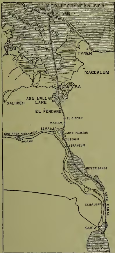
Said the canal crosses Lake Menzaleh (28 miles long); and three more—Lake Ballah, Lake Timsah (5 miles long), and the Bitter Lakes (23 miles)—are traversed to the south of it. The highest point or elevation that was cut through does not exceed 50 feet above sea-level. At intervals of 5 or 6 miles 'sidings' or side-basins are provided to enable vessels to pass one another. At the end of a dozen years the traffic had increased so enormously that a second canal began to be talked about; and in 1886 the task of widening, and also deepening, the existing canal was commenced. By 1890 the canal had been deepened to 28 feet, and widened between Port Said and the Bitter Lakes to 144 feet, and from the Bitter Lakes to Suez to 213 feet.
The increasing use of screw-propellers in steam-vessels, with the enormous shortening of sea-voyages to India, China, and Australia effected by the canal, rapidly increased the tonnage of vessels using this route. The subjoined table gives the salient particulars :
| Year. | No. of Vessels. | Gross Tonnage. | Receipts. |
|---|---|---|---|
| 1870..... | 486 | 654,915 | £206,373 |
| 1875..... | 1264 | 2,423,672 | 994,375 |
| 1880..... | 2026 | 4,344,519 | 1,629,577 |
| 1885..... | 3024 | 8,985,411 | 2,488,297 |
| 1890..... | 3389 | 9,749,129 | 2,680,436 |
| 1895..... | 3434 | 11,533,637 | 3,124,149 |
| 1898..... | 2986 | 7,899,373 | 3,024,280 |
Both in respect of tonnage and of the number of vessels Great Britain greatly exceeds all other nations put together; in 1896, 2162 of the vessels were British, their tonnage reaching the aggregate of 8,057,706 tons. Since 1886 the time of making the transit through the canal has been greatly accelerated. In that year a vessel took on an average thirty-six hours to get through; but in 1898 the average time of passage was fifteen hours thirty-six minutes. Moreover, since 1st March 1887 the electric light has been used to light the way during the night. The first year that this adjunct was in operation it was used by 395 vessels out of 3137; in the year 1896, 3217 out of 3409 used it. The cost of getting through by electric light amounts to about £10 for each vessel. Besides 100,000 founders' shares, the original capital of the company consisted of 400,000 shares of £20 each, making a sum total of £8,000,000. Of these shares 176,602, which belonged to the khedive, were purchased from him by Beaconsfield for the British government in 1875 for the sum of £3,976,582, although he had mortgaged the interest on them up to the year 1894. Since the formation of the company additional obligations have been incurred to the amount of £8,110,567. All net earnings that remain after 5 per cent. interest has been paid are divided in the following proportions: 71 per cent. as dividend to the shareholders, 15 per cent. to the khedive, 10 per cent. to the holders of founders' shares, 2 per cent. to the managing directors, and 2 per cent. to the company's employees. In 1898 the net profits thus divided amounted to £1,600,923. The widening of the canal is being carried out.
See F. de Lesseps, Le Canal de Suez (Paris, 1875), and Lettres, Journal, et Documents à l'Histoire du Canal de Suez (5 vols. Paris, 1881); Journal of the Statistical Society (June 1887); Suez Canal, Returns of Shipping and Tonnage, 1888-91 (Lond. 1891); D. A. Cameron, Egypt in the Nineteenth Century (1898); and other recent books on Egypt (q.v.).